
The Kentucky Geological Survey has archived this material, meaning (1) it is for reference, research, or recordkeeping; (2) it was created before April 24, 2026; (3) and the material has not been changed or altered since being archived. Please refer to our KGS Accessibility page for more information.
KGS Home > Geology of Kentucky
Depositional History of the Fort Payne Formation
(Modified from Greb, S.F. and others, 2008, with permission of the Kentucky chapter of the American Institute of Professional Geologists)
To understand the lithologic and thickness variability of the Fort Payne Formation, it helps to understand its relationship to the Borden Formation. Although the Borden and Fort Payne Formations both overlie the Chattanooga Shale, the Borden was deposited first, as a series of west-prograding delta lobes (labeled Borden delta in Figure 1), prior to deposition of the Fort Payne Formation.
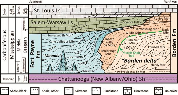
Figure 1. Generalized stratigraphic relationship of the Fort Payne and Borden Formations in southeastern Kentucky.
The various members of the Borden Formation represent different facies of the prograding subaqueous delta. The Floyds Knob bed is a glauconite-rich unit that marks the contact between the Fort Payne and Borden Formations (Fig. 1). Glauconite is a green mineral of the mica group (a phyllosilicate), which is characteristic of slow sedimentation in marine continental slope environments. Hence, the Floyds Knob Bed has been inferred to represent the face of an abandoned Borden delta lobe upon which glauconite slowly accumulated (Peterson and Kepferle, 1970). The delta lobe is estimated to have had more than 150 ft of relief (Fig. 1)(Sable and Dever, 1990; Khetani and Read, 2002; Krause and others, 2002).
The Fort Payne Formation was deposited in the sediment-starved basin in front of the abandoned Borden delta lobe. The broad environmental setting that best fits the lateral variability, thickness changes, lithologies, fossils, and other features seen in the Fort Payne (see Typical Depositional Facies), is a marine, southwest-dipping ramp. This ramp filled the basin west of the Borden front with (1) clastic sediments derived from the abandoned Borden delta lobe by a variety of mass flows and submarine channel processes (turbidites, slumps, debrites), (2) marine carbonates, and (3) the famous Waulsortian-like mud mounds or buildups (MacQuown and Perkins, 1982; Ausich and Meyer, 1990; Sable and Dever, 1990; Meyer and others, 1995; Lasemi and others, 1998, 2003; Khetani and Read, 2002; Krause and others, 2002; 2004; Lumsden, 2003).
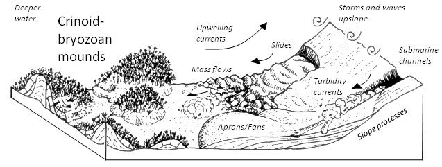
Figure 2. Model of lower Fort Payne deposition in the Lake Cumberland area. No scale inferred.
A lack of shallow-water bedding features (tidal lamination, ripples, etc.) and diagnostic shallow-water bioturbation confirms the likelihood that the mound interval was deposited in relatively deep water. Water depths were still in the photic zone, however, because fossil benthic dasyclad green algae have been found in the wackestones and packstones (Ausich and Meyer, 1990; Meyer and others, 1995; Khetani and Read, 2002). Details of mound facies deposition can be found at typical mud mound facies. Some mounds appear to have developed above local paleotopographic highs (MacQuown and Perkins, 1982; Lumsden, 1988; Ausich and Meyer, 1990; Stapor and Knox, 1995). Suspended sediment in the water was trapped (baffled) by crinoids and fenestrate bryozoans on these highs, creating a kind of self-perpetuating mounding, with crinoids and bryozoans continually recolonizing the growing mounds (MacQouwn and Perkins, 1982; Ausich and Meyer, 1990; Stapor and Knox, 1995). Mound growth was also influenced by storm waves and slope processes (Ausich and Meyer, 1990; Meyer and others, 1995). ). Ausich and Meyer (1990) inferred that some of the sheet-form siltstone deposits in the Fort Payne Formation in the areas around the mounds might represent carbonate aprons (see Mullins and Cook, 1986), which are somewhat analogous to submarine fans, but formed from carbonate muds off of carbonate banks. Submarine fans would be sourced by submarine channels and numerous smaller distributary submarine channels, which cn be seen in outcrops along Lake Cumberland.
Regional correlations of the Fort Payne Formation with equivalent Mississippian units in southern Illinois and Missouri suggest that the Fort Payne ramp connected westward to a deeper, cool-water basin (Fig. 3). The deeper basin was approximately located over the present-day Mississippi Embayment and extended southwest into the Ouachita Trough (Lasemi and others, 1998; 2003). The trough was the southern margin of the continent at that time. Cold, upwelling waters from the Trough were a source of nutrients for the mounds, and likely supplied the wealth of siliceous sponge spicules (microscopic skeletal fragments of sponges), which are common in Fort Payne sediments. Lasemi and others (2003) noted that the Arkansas Novaculite is a siliceous unit, which may be partly equivalent to Fort Payne accumulation. The source of silica in the novaculite is sponge spicules.
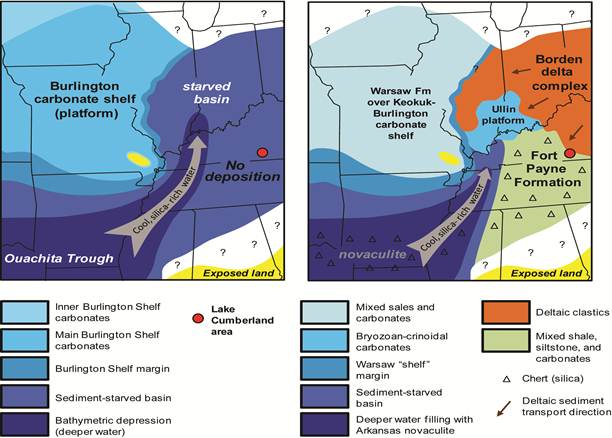
Figure 2. Paleogeographic setting of the Fort Payne and equivalent strata,
which began in a starved basin (A) that was subsequently filled (B) in front of the Borden delta complex
(modified from Lasemi and others, 2003, Fig. 11, included here with permission of authors and SEPM (Society for Sedimentary Geology).
References
Back to top of Geology of the Fort Payne Formation