
The Kentucky Geological Survey has archived this material, meaning (1) it is for reference, research, or recordkeeping; (2) it was created before April 24, 2026; (3) and the material has not been changed or altered since being archived. Please refer to our KGS Accessibility page for more information.
KGS Home > Geology of Kentucky
Greasy Creek Mound
Location: Along the northern and southern shore of Greasy Creek, Lake Cumberland.
Nad-83 Decimal Degree (lat, long): 36.975626, -85.034454
7.5-minute Quadrangle: Jamestown (Thaden and Lewis, 1962)
County, State: Russell, Kentucky
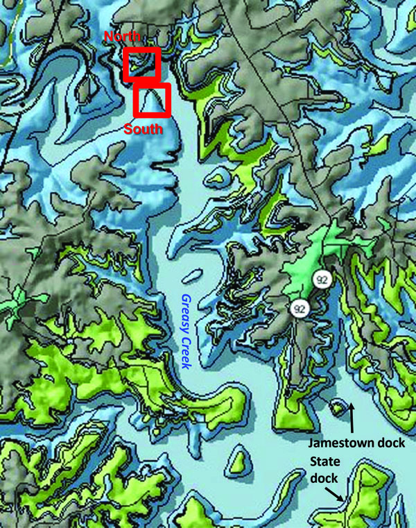
Figure 1. Location of the large buildup on Greasy Creek and geology of the area. From the Kentucky Geological Survey's geologic map information service, based on Thaden and Lewis (1962).
Overview: This buildup is only accessible by boat. It is a large mound, and may be composite buildup (multiple mounds that merged together). Characteristic facies are exposed on both sides of the lake/creek.
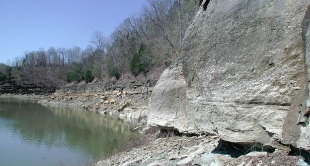
Figure 2. A large mound, or composite mound, is exposed on both shores of Greasy Creek.
View is looking west along the north shore down the flank of the carbonate (wackestone) buildup. Lake level is 678.96 ft.
Description: A large buildup is exposed on both the north and south shore of the upper reaches of Greasy Creek (Figs. 2-3). The two exposures may represent a single large mound, cut by the creek, a compound or composite mound, or multiple, closely spaced mounds. The thickest core shales (at the apex of the mud mounds) are on the southeastern exposure (outcrop E in Figure 3) and northern exposure (stop 2 in Figure 3). If the apexes connect, they define a somewhat elongate core at least 2,000 ft (0.6 km) long. It is also possible that the thick green core shale in the Greasy Creek (north) and Greasy Creek (south) exposures actually represents two separate mounds that grew together into a composite or compound mound. The green core shale and overlying carbonate (wackestone) buildups are different than the area of reef limestones mapped on the Jamestown geologic quadrangle map (Thaden and Lewis, 1962). What was mapped as reefal limestone appears to combine multiple mounds or parts of mounds, and possibly overlying carbonates, into one geologic unit.
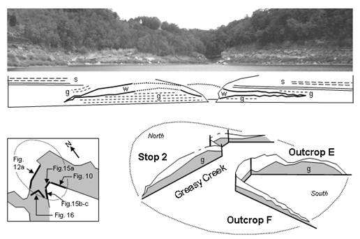
Figure 3. Three-dimensional view of the Greasy Creek mound(s).
View is looking east toward stop 2 and outcrop F, which is the backside of outcrop E. Green core shale is indicated by "g" in the schematic diagram.
The diagram is based on the photographs, with no scale inferred (lake level is 678.96 ft).
From Greb and others (2008, Fig. 16). Need to change Figure numbers in the graphic
North Shore
The large mounds on both shores expose cross sections of the typical facies associated with the Fort Payne mud mounds. The mound on the north shore (Fig. 4) was stop 2 in Greb and others (2008).
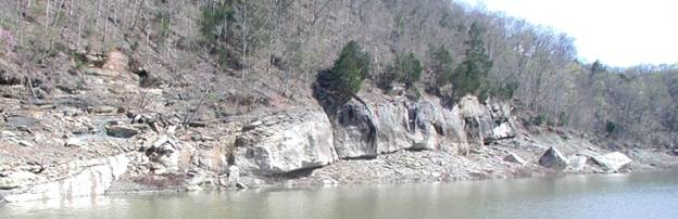
Figure 4. Large mud mound exposed on the north shore of Greasy Creek. Lake level is 678.96 ft.
The green core shale is well exposed in this mound at low water (below approximately 690 ft) (Figs. 4-5). The shale contains abundant crinoid and bryozoan debris (Fig. 6). Several thin, iron-stained, crinoidal rudestones (coarse-grained crinoidal carbonates) also occur and help show the upward-building shape of the core shale within the otherwise fissile shale (Fig. 7).
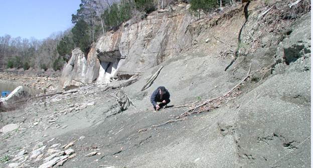
Figure 5. Green core shale facies overlain by carbonate buildup (mostly massive wackestone)
on the north shore of Greasy Creek.
Dave Meyer for scale. Lake level is 678.96 ft.
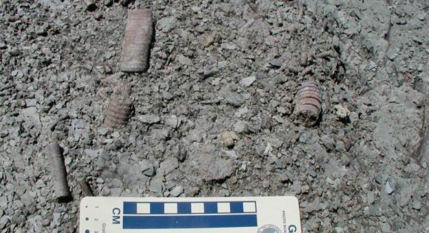
Figure 6. The green core shale contains abundant fossil crinoid columnals and bryozoan frond fragments.
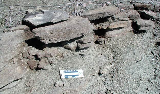
Figure 7. Thin, dipping, iron-stained carbonates with coarse,
crinoidal debris occur within the green core shale, and help show the sloping, mound shape of the facies.
The core shale is sharply truncated by a cliff-forming carbonate buildup (Figs. 2, 4, 8). The carbonate is thickest off of the apex of the core shale. The west side of the carbonate buildup is shown in Figure 8. The east side is exposed in the small tributary to the east of this stop. The base of the carbonate is a thin packstone, but the majority of the cliff is the massive wackestone facies of Krause and Meyer (2004). The massive wackestone is draped by a series of crinoidal grainstones, which thicken down the flanks of the mound.
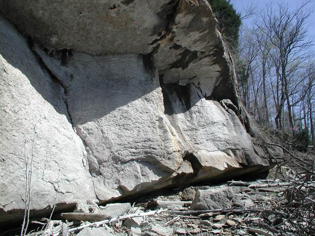
Figure 8. Thick carbonate buildup above green core shale at Greasy Creek. The thickest part of the carbonate is along the flank of the core shale.
A thin packstone occurs at the base of the outcrop, but most of the cliff and overhang is a massive wackestone.
South Shore
The mound on the south shore (Fig. 9) may be a separate buildup or part of a much larger composite mound, which was originally attached to the buildup on the north shore (Fig. 3). On the south side of the creek, beds dip into the shoreline. Some beds drape the mound on its flank, and others are partly slumped (Fig. 10). On the western flank of the buildup the entire limestone (10 to 15 ft) was deformed into a set of large-amplitude wavey to wrinkled beds (Figs. 11B-C). Underlying strata are covered, so whether the underlying unit was also deformed is uncertain. Soft-sediment deformation and slumping are common on the downslope sides of the mounds, and in overlying shales and siltstones that cap the mounds. Look at bedding above the mound flanks on both the north and south shore of Greasy Creek and examine the dip of beds off of the flanks of the carbonate buildup.
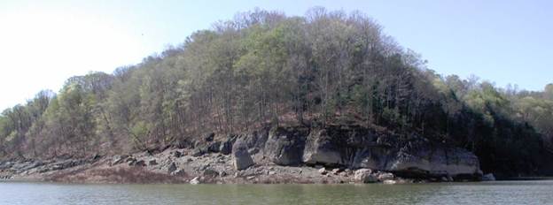
Figure 9. Thick carbonate buildup above green core shale along the south shore of Greasy Creek.
Beds dip into the outcrop away from the creek.
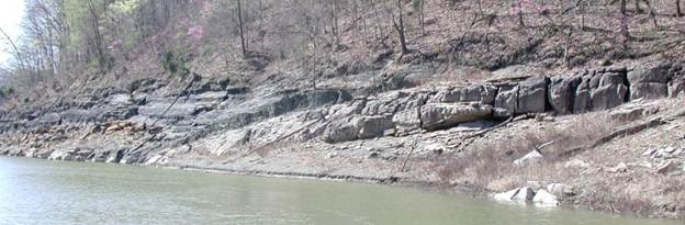
Figure 10. Southeastern flank of the mound on the south shore, showing thinning core shale,
wackestone carbonate, draping green shales, and partly slumped green shales.
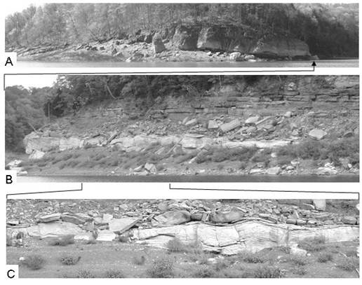
Figure 11. Greasy Creek mound (southwest side) as viewed (A) from the north side of Greasy Creek.
The flanking wackestone (B-C) thins westward and becomes "wrinkled" downslope. Lake level for photo A is 695.3 ft,
and for photos B-C is 678.96 ft). From Greb and others (2008, Fig. 15).
References
Continue to Hammon Creek Mound
Back to Fort Payne Formation Field Trip in the Lake Cumberland Region
Back to top of Geology of the Fort Payne Formation