
The Kentucky Geological Survey has archived this material, meaning (1) it is for reference, research, or recordkeeping; (2) it was created before April 24, 2026; (3) and the material has not been changed or altered since being archived. Please refer to our KGS Accessibility page for more information.
KGS Home > Geology of Kentucky
Harmon Creek Mound
Location: Along the south shore of Lake Cumberland, on the eastern side of the mouth of Harmon Creek.
Nad-83 Decimal Degree (lat, long): 36.917318, -84.957590
7.5-minute Quadrangle: Jabez (Thaden and Lewis, 1966)
County, State: Wayne, Kentucky
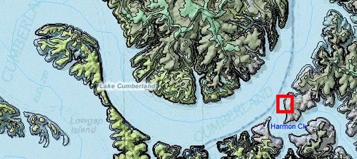
Figure 1. Location of the Harmon Creek mound.
Overview: The Harmon Creek buildup crops out along Lake Cumberland at the mouth of Harmon Creek, and is only accessible by boat. The mud mound was first described by Lewis and Potter (1978, stop 5, Figs. 25-26), and was also included in Meyer and Ausich's (1992) field trip guidebook.
Photographs for this report were taken on May 11, 2007, when lake level was low, at 680 ft.
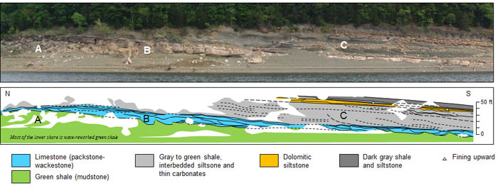
Figure 2. Interpretation of the Harmon Creek mound, Fort Payne Formation, showing core shale (A);
flanking carbonate mound (B); and overlying green and gray shales, siltstones, and interbedded carbonates (C).
Vertical scale is approximated.
Description: The Harmon Creek mound is approximately 600 ft long. Most of the southern flank of the mound is exposed along Harmon Creek. Only part of the northern flank is exposed on the lake side of the exposure. The mound has a well-developed green core shale with common bryozoan and crinoidal debris. Presuming a green shale core to the base of the exposure, the core shale has more than 35 ft of relief (Fig. 3). The core shale is overlain by 12 to 15 feet of crinoidal, carbonate wackestones and packestones (Figs. 3), similar to other mounds on the lake. The carbonates on the southern flank of the mound are much thicker (12 to 15 ft) and better exposed than the carbonates on the northern flank (<6 ft) of the mound. A packestone layer drapes both flanks of the mound (Fig. 4), similar to the layering at the Pleasant Hill mound. The base of the thick wackestone sharply overlies the green core shale (Fig. 3).
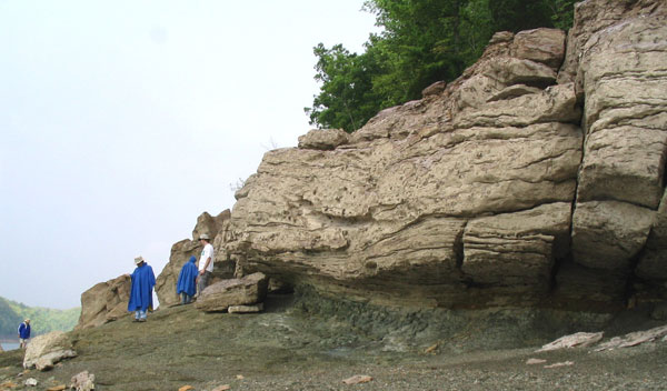
Figure 3. Sharp, basal contact of carbonate (wackestone) flanking beds
above the green core shale at Harmon Creek, Lake Cumberland.
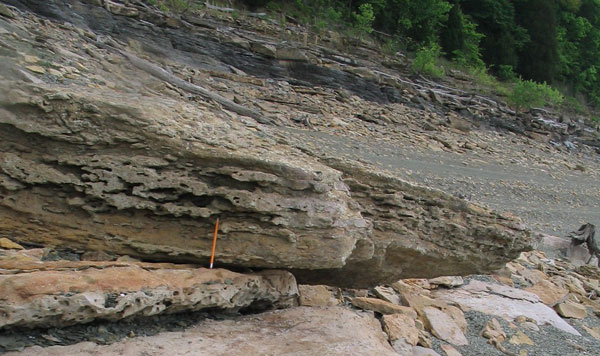
Figure 4. Capping packestone layer of the Harmon Creek buuildup, Fort Payne Formation, Lake Cumberland.
The carbonate part of the buildup contains multiple discordances (Figs. 2, 5), suggesting slumping down the flanks of the mound during accumulation. These are most obvious on the lower southern flank, which is submerged at higher water. Not only is there evidence of slumping in the carbonates, but the overlying gray and green shale also exhibits varying scales of discordances, suggesting downslope rotation off of the flanks of the underlying mound.
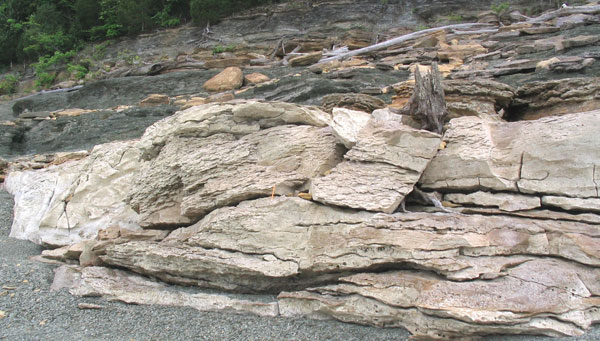
Figure 5. Wackestone on southern flank of the Harmon Creek mound, Fort Payne Formation, Lake Cumberland.
Sigmoidal contacts between bedding suggest downslope rotation (slumping and sliding) along the flanks.
Ripple laminae are common.
Meyer and Ausich (1992) listed a wide array of fossils from this mound including 19 genera of crinoids, 16 genera of bryozoan, 16 genera of brachiopods, and assorted blastoids, gastropods, bivalves, trilobites, ostracods, and sponges. Monobathrid camerates dominate the crinoids, while fenestrate genera dominate the bryozoa. Filter-feeding pelamatazoans are inferred to have trapped sediment to help build up the mounds. Moreover, the abundance of other fossils at this, and other mounds, shows that crinoid and bryozoan gardens associated with the mounds provided habitat for diverse invertebrate marine creatures.
References
Continue to Harmon Creek, Jabez Sandstone
Back to Fort Payne Formation Field Trip in the Lake Cumberland Region
Back to top of Geology of the Fort Payne Formation