
The Kentucky Geological Survey has archived this material, meaning (1) it is for reference, research, or recordkeeping; (2) it was created before April 24, 2026; (3) and the material has not been changed or altered since being archived. Please refer to our KGS Accessibility page for more information.
KGS Home > Geology of Kentucky
Wolf Creek Paleoslump
Location: On Lake Cumberland, south shore of Wolf Creek, east of the Wolf Creek paleochannel.
Nad-83 Decimal Degree (lat, long): 36.949120, -84.996184
7.5-minute Quadrangle: Jabez (Thaden and Lewis, 1966)
County, State: Russell, Kentucky
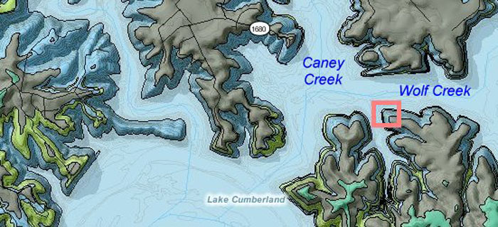
Figure 1. Location of paleoslump in the Fort Payne Formation, Wolf Creek, Lake Cumberland.
Overview: A paleoslump along a small tributary of Wolf Creek provides a three-dimensional view of soft-sediment deformation and slumping in the Fort Payne Formation. The outcrop is only accessible by boat. Photographs of this deformation were shown in Lewis and Potter (1978, Figs. 20-21).
Images in this report were taken on August 21, 2008, when lake level was low, at 680 ft. Deformed bedding is exposed when water level is less than approximately 700 ft.
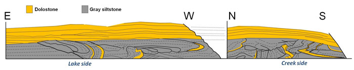
Figure 2. Diagram of (A) paleoslump and soft-sediment deformation in the Fort Payne Formation
along Wolf Creek, Lake Cumberland. Views of deformation along
(B) Wolf Creek, and (C) the tributary to Wolf Creek. From Greb and others (2008, Fig. 26).
Description: On the lake side (Wolf Creek part) of this stop, a paleoslump overlies a sharp, listric contact with significant relief. The paleoslump is truncated by flat-lying, interbedded siltstones and dolostones. The capping layer is continuous along this part of the lake (Figs. 2-4). Bedding within the deformed interval consists of a series of elongate folds, which are well-defined by a series of resistant, iron-stained dolostones. Several glide planes offset bedding.
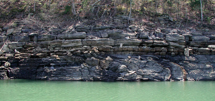
Figure 3. View of deformation along listric glide plane in the Fort Payne Formation along Wolf Creek, Lake Cumberland.
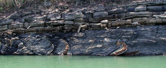
Figure 4. View of deformation along listric glide plane in the Fort Payne Formation
along Wolf Creek, Lake Cumberland. This view is west of Figure 3.
Where the small creek intersects the lake (Wolf Creek), bedding in the paleoslump can be viewed at right angles to the lake exposures, providing a three-dimensional view. Bedding along the small creek is crosscut by multiple glide planes (Figs. 2, 5-6), and complex folds. This outcrop is a good illustration of the complexity of deformation in the Fort Payne Formation, as well as the significance of the orientation of the exposure to the appearance of deformation.
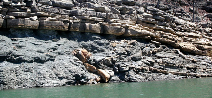
Figure 5. View of complex deformation in the Fort Payne Formation along a tributary to Wolf Creek,
Lake Cumberland. A detail of the most intensely deformed interval is shown in Figure 6.
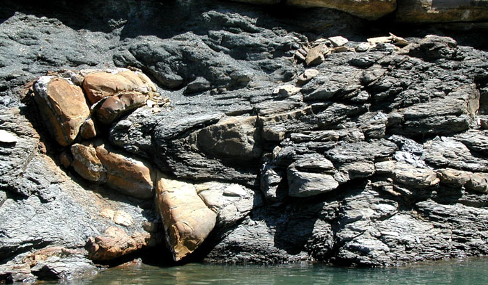
Figure 6. View of complex deformation in the Fort Payne Formation along a tributary to Wolf Creek, Lake Cumberland.
References
Back to Fort Payne Formation Field Trip in the Lake Cumberland Region
Back to top of Geology of the Fort Payne Formation