
KGS Home > Geology of Kentucky
Oil Production from Fort Payne Buildups
Paul E. Potter and Stephen F. Greb
The carbonate buildups exposed on Lake Cumberland are similar to those that produced oil from limestones in the Fort Payne Formation, from reservoirs 5 to 40 ft above the top of the Chattanooga Shale in south-central Kentucky (Munn, 1914, p. 26–29; Wilson, 1971). Munn (1914) included pictures of the massive mudstone (shale) core (Plates 1 and 2), from producing fields, but recognized that other associated limestones in the Fort Payne (the well-washed adjacent and capping limestones with inclined bedding) could also be reservoirs. Whatever its origin, the green core mudstone (shale) facilitated limestone buildups (which locally form reservoirs) and the traps around and above them. Fort Payne buildup reservoirs were called the Beaver Creek sand by drillers, although all were composed of carbonates, rather than sandstones. Oil was historically produced from the Beaver Creek sand in parts of Wayne County. Fort Payne production was also reported from the Corder stray. The Corder stray is a driller’s term for a limestone reservoir near the top of the Fort Payne Formation (stratigraphically above the Beaver Creek stray). Production from these two reservoirs in Kentucky was initially from very shallow wells; only 500 to 700 feet deep. Many wells were drilled early in the twentieth century (about the same time as the discovery of the East Texas fields), and production was subsequently found to the west in Metcalfe County in 1959, and to the southeast in the Oneida Field of Scott County, Tenn., in 1982 (Wilson, 1971; MacQuown and Perkins, 1982; Milici, 1996). Differences between the types of reservoirs in Tennessee and Kentucky buildups are discussed in Marcher (1962), Statler (1971), and Kuslansky and Friedman (1984).
More than 7 million barrels of oil have been produced from the Fort Payne Formation in Kentucky and Tennessee (Milici, 1996). Buildups in producing fields are elliptical in plan view, and generally 30 to 75 ft in thickness (Wilson, 1971; Lewis and Potter, 1978; Milici, 1996). Figures 1 through 3 show an example of a typical producing field. Most producing wells are single-well fields. Fields that produce from multiple wells are elliptical in plan view, so single-well mounds are inferred to have similar trends. The thickness of the buildups in producing fields is comparable to that of the buildups exposed along lake Cumberland and Dale Hollow Lake Producing oil fields range in diameter from mounds defined by single wells to mounds (or perhaps mound complexes) defined by 25 or more wells and having widths of tens of thousands of feet. Most fields are less than 3 km in diameter (Statler, 1971; Wilson, 1971; MacQuown and Perkins, 1982; Kuslansky and Friedman, 1984). Sadly, only a few studies have been published on mound-facies reservoirs in the subsurface of Kentucky and Tennessee. The exposures at Lake Cumberland and Dale Hollow Lake provide an opportunity to examine facies variability and details within the mound structures that should be relatable to reservoir properties in the subsurface of these fields, where data are more limited.
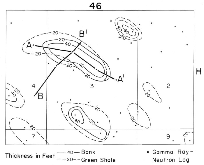
Figure 1. Map of inferred carbonate buildups (Beaver Creek “sands”) in the Fort Payne Formation from an oil field in Metcalf County, Kentucky.
The thickness of carbonate buildups (banks) and underlying green shale mounds are inferred from down-hole geophysical logs.
Cross sections showing log profiles are provided in Figures 2 and 3. North is toward the top of the figure.
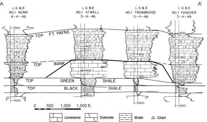
Figure 2. Cross section of a producing Fort Payne buildup along the long axis of a buildup.
See Figure 1 for location. Black Shale=Devonian Chattanooga Shale. An inferred carbonate buildup is shown by thicker black lines.
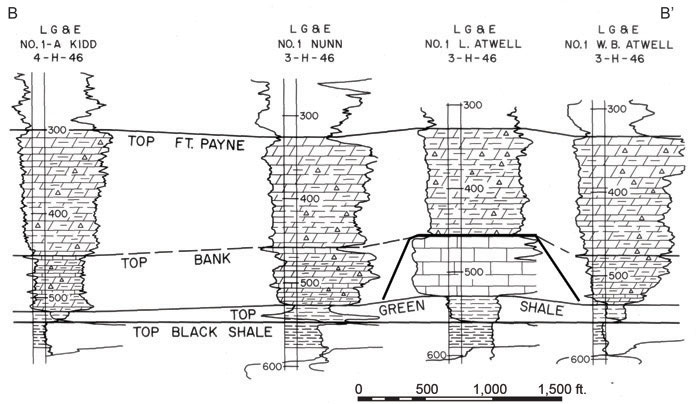
Figure 3. Cross section of a producing Fort Payne buildup across the short-axis of an inferred oval-shaped buildup
. See Figure 1 for location. Many of the Fort Payne buildups (Beaver Creek “sands”) are single well fields.
Black Shale=Devonian Chattanooga Shale. An inferred carbonate buildup is shown by thicker black lines
References
Back to top of Geology of the Fort Payne Formation