
The Kentucky Geological Survey has archived this material, meaning (1) it is for reference, research, or recordkeeping; (2) it was created before April 24, 2026; (3) and the material has not been changed or altered since being archived. Please refer to our KGS Accessibility page for more information.
KGS Home > Geology of Kentucky
Fort Payne Formation - Mud Mounds (Buildups)
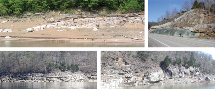
The famous Fort Payne mud mounds (at least in the Lake Cumberland and Dale Hollow Lake areas) occur in the lower part of the Fort Payne Formation (see, for example, Knox and Stapor, 1973; Lewis and Potter, 1978). They are Middle Mississippian (late Osagean) in age. Generally, the base of the mounds is a short distance above the Maury shale equivalent at the base of the Fort Payne Formation. These mounds were mapped on the Jabez and Jamestown 7.5-minute geological quadrangle maps as reef limestones (Thaden and Lewis, 1962, 1966), but are actually deeper water biohermal buildups analogous to European Waulsortian mounds. Similarities and differences between the Fort Payne buildups and Waulsortian mounds are summarized in the typical mud mound facies part of the website, as are descriptions and photographs of the mounds in the Lake Cumberland and Dale Hollow Lake areas.
Continue to Jabez, Knifley, and Cane Valley Members
Back to Stratigraphy of the Fort Payne Formation
Back to top of Geology of the Fort Payne Formation