
The Kentucky Geological Survey has archived this material, meaning (1) it is for reference, research, or recordkeeping; (2) it was created before April 24, 2026; (3) and the material has not been changed or altered since being archived. Please refer to our KGS Accessibility page for more information.
KGS Home > Oil and Gas
General Structure and Kinematics of the Rome Trough, Eastern Kentucky
Contact: Dave Harris
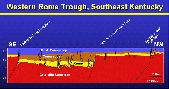
The cross section crosses the Rockcastle River Uplift on the southeast. The Rockcastle River Fault Zone
is here a thrust fault, however farther to the northeast, the fault shows normal displacement. Vertical
is approximately 3.5x.
Under the direction of Jim Drahovzal, Tina White is completing Master's thesis studies (University of Kentucky) on the general structure and kinematics of the Rome Trough in Kentucky. The study is based on newly available seismic reflection data for the trough, but has confirmed most of the general structure and basement geometry shown earlier by Drahovzal and Noger (1995). An exception is the nature of the Rockcastle River Uplift along the southwestern edge of the trough. The uplift formerly believed to be cored by a north-dipping normal fault, is actually cored by a south-dipping thrust fault. The fault has an apparent considerable strike-slip component, based on the splaying of the fault higher in the section and the development of a positive flower structure and draping. Also significant is the more than 4,000 feet of down-to-the-east basement displacement that likely parallels the axis of the Paint Creek Uplift in Johnson County, Kentucky. The faults bounding this north-south low apparently were reactivated as wrench faults in the development of the uplift. The basement character of this feature was not recorded in the 1995 mapping because of the lack of available deep data at that time. These new data indicate a much more complex polyphase evolution for the trough than formerly understood and suggest several new scenarios for potential oil and gas accumulations.
Abstracts, Presentations, and Articles
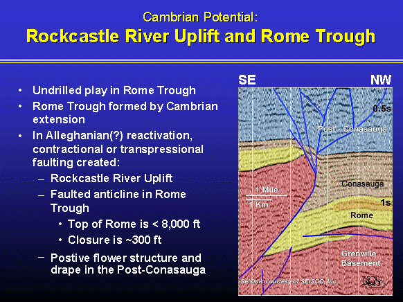 |
Approximately 2.7x vertical exaggeration. |
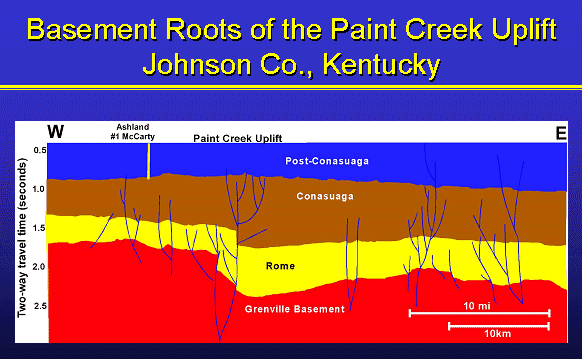 |
Approximately 3-5x vertical exaggeration. |
For additional information, see the Rome Trough Consortium
![]()