| Topography | ||
|
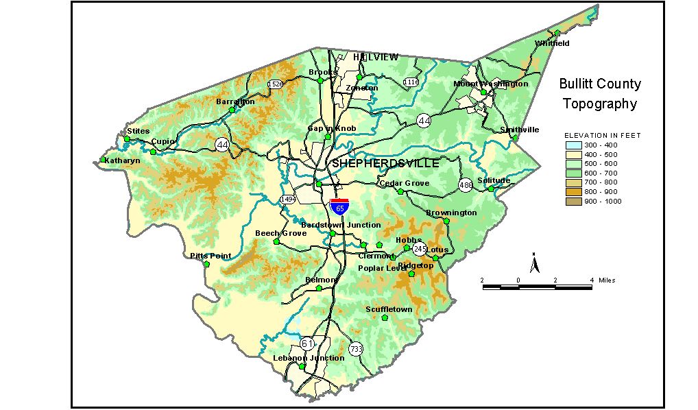
Discussion from McGrain and Currens (1978) Bullitt
County, located in northern Kentucky immediately south of the Louisville
area, has a diverse topography. The extreme eastern tip of the county
is in the rolling hills of the Outer Bluegrass Region. The western part
of the county is in the area of rugged topography of the Knobs and dissected
upland behind Muldraugh Hill (Highland Rim escarpment). Between these
eastern and western parts of the county is a region containing some
broad flat areas -- an upland plain developed on resistant rocks and
wide alluviated valleys carved from soft rocks. Muldraugh Hill, an east-facing cuesta, and the isolated round hills
or knobs carved from this upland are the most conspicuous topographic
features of Bullitt County and contain both the highest elevations and
the sites of greatest local relief. Slopes are steep, but cliffs are
rare. Individual knobs may rise 400 feet or more above the valleys of
Rolling Fork and Salt River. The highest elevation in the county is
998 feet, the top of a knob some 3 1/2 miles northeast of Lebanon Junction.
Elevations of some other knobs are Buttonmold Knob, 804 feet; Dawson
Knob, 980 feet; Phelps Knob, 789 feet; and the knob on which the lookout
tower in Bernheim Forest is located, 921 feet. Precise elevations have
been determined for many more peaks, and this information can be obtained
from individual topographic maps. The hills and ridges at the eastern edge of Muldraugh Hill may attain
elevations in excess of 900 feet. Two points adjacent to Brooks Hill
have elevations of 912 and 917 feet, some 400 feet above the lowland
immediately to the east. This upland area decreases in elevation toward
the western border of the county where ridgetops are generally 700 to
750 feet in elevation, approximately 300 feet above the floodplain of
the Ohio River. The 7.5-minute topographic quadrangle maps that cover Bullitt County
are shown, by name and by index code (Kentucky Natural Resources and
Environmental Protection Cabinet) on the index
map. Previous--Next--Back to "Groundwater Resources in Kentucky"
|
||