| Topography | ||
|
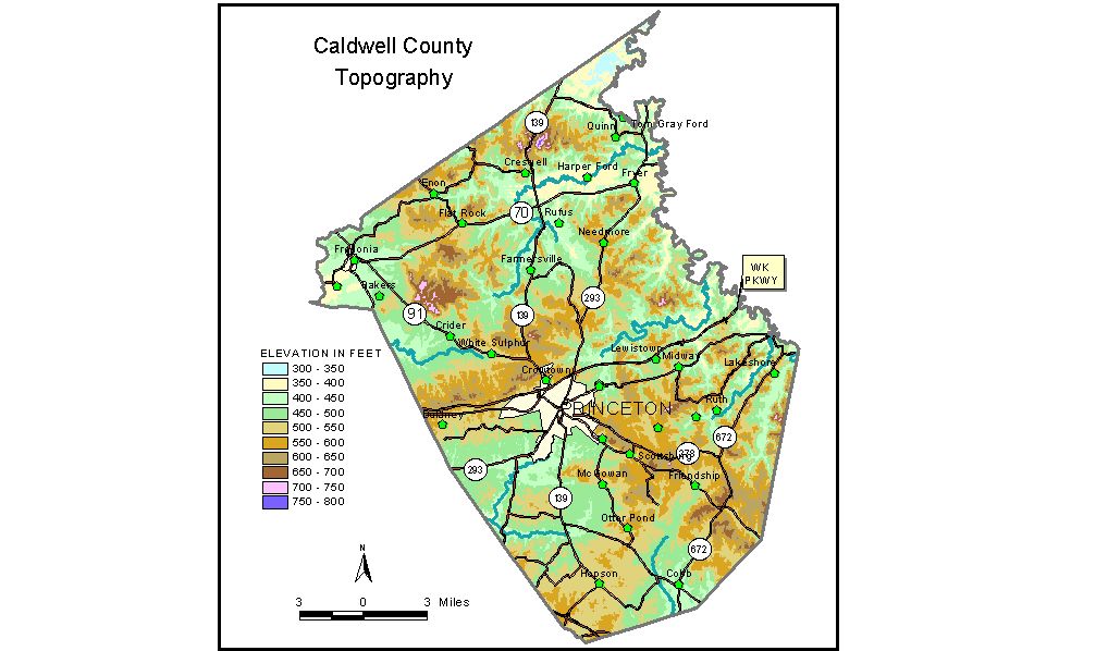
Discussion from McGrain and Currens (1978) Caldwell
County, located in western Kentucky, has a diverse topography. Portions
of southern and western Caldwell County lie on a well-developed sinkhole
plain that extends eastward to the Bowling Green area of south-central
Kentucky. Sinkholes, sinking creeks, springs, and other features associated
with underground drainage in a limestone terrane are found here. Portions of eastern and northern Caldwell County touch the fringes
of the Western Kentucky Coal field. The most rugged topography, highest
elevations, and greatest local relief in the county are found here.
Locally, there are precipitous bluffs, such as Barnes Bluff and Hunters
Bluff adjacent to U. S. Highway 62 in the eastern portion of the county;
waterfalls; and high knobs and ridges. The highest elevation in the county appears to be 767 feet, on a ridge
just east of Kentucky Highway 139 about 6 miles north of Farmersville.
A comparable elevation of 766 feet is found on top of Bald Knob about
5 miles east of Princeton. The lowest elevations are found along Tradewater River (which marks
the northeastern boundary of the county) and its tributaries, and Livingston
Creek, a tributary of Cumberland River, (Livingston Creek joins Cumberland
River about 10 miles below Barkley Dam.) The lowest elevation of 339
feet is found both where Tradewater River and where Livingston Creek
leave the county. The gradient of Tradewater River is low; drainage
is slow and marshes are common. Part of the county is in the mineral region known as the Illinois-Kentucky
fluorspar district, which is characterized by a large number of fractures
in the rocks. Effects of the faulting are reflected in the topography
of the area as straight ridges and linear arrangement of sinkholes. The elevation of Cobb is 460 feet; Crider, 459 feet; Farmersville, 472 feet; Fredonia, 420 feet; and Princeton, at the courthouse, 495 feet. Cedar Bluff, a conspicuous landmark on the Dripping Springs escarpment 2 miles southeast of Princeton, is 680 feet. Normal pool elevation of Lake Beshear is 410 feet. During periods of storage of flood waters in Lake Barkley, the reservoir may back up Eddy Creek into Caldwell County to an elevation of 375 feet. (The normal pool level of Lake Barkley is 359 feet.) The 7.5-minute topographic quadrangle maps that cover the county are
shown, by name and by index code (Kentucky Natural Resources and Environmental
Protection Cabinet) on the index
map. Previous--Next--Back to "Groundwater Resources in Kentucky"
|
||