| Topography | ||
|
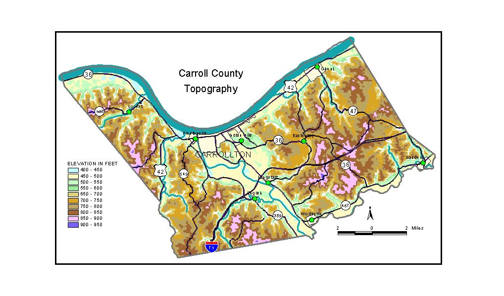
Discussion from McGrain and Currens (1978) Carroll County is located in north-central Kentucky in the Outer Bluegrass Region. The Ohio River, with normal pool elevation of 420 feet, is the northern boundary of the county. The Kentucky River enters the county at Worthville and joins the Ohio between Carrollton and Prestonville. The normal pool level of the Kentucky River below Lock No. 1, 4 miles upstream from the Ohio, is 420 feet; normal pool level above Lock No. 1 is 428 feet. The area is well dissected and is characterized by narrow valleys (except along major streams), steep slopes, and narrow ridges. Ridgetops with elevations between 800 and 900 feet are common. The highest elevation is 940 feet, a ridge about 1 1/2 miles north of Worthville. The valley of Buffalo Creek, just 1/4 mile west of this ridge, is 400 feet lower. Bluffs along the Ohio, Kentucky, and Little Kentucky Rivers and Eagle Creek commonly rise 300 feet or more above the valleys. The elevation of the alluviated valley of the Ohio River ranges between 450 and 490 feet. Elevations in the valleys of the Kentucky and Little Kentucky Rivers and Eagle and Mill Creeks are similar. General Butler State Park, at the southeastern edge of Carrollton, is developed on a cutoff meander core. The hills and ridges in the park are between 200 and 300 feet above the surrounding alluviated valleys. The highest elevation in the park is 780 feet, a knob near the northwestern corner. The elevation of Carrollton, the county seat, is 485 feet. Elevations of other communities are English, 474 feet; Ghent, 495 feet; Prestonville, 475 feet; Sanders, 486 feet; and Worthville, 486 feet. The 7.5-minute topographic quadrangle maps that cover Carroll County
are shown, by name and by index code (Kentucky Natural Resources and
Environmental Protection Cabinet) on the index
map. Previous--Next--Back to "Groundwater Resources in Kentucky"
|
||