| Topography | ||
|
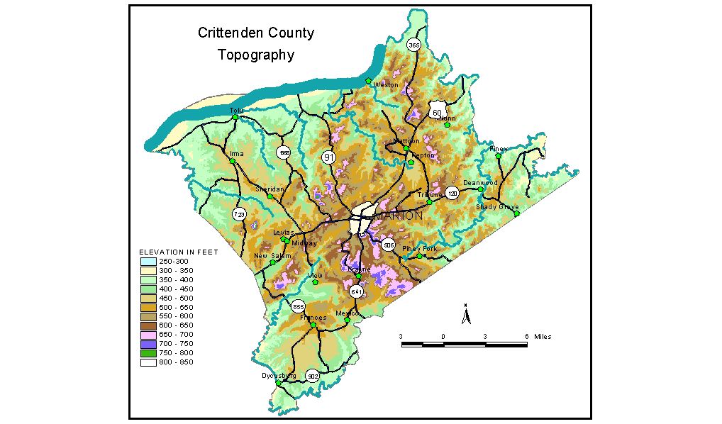
Discussion from McGrain and Currens (1978) Crittenden
County is located in the Western Kentucky Fluorspar District of
the Mississippian Plateaus area of extreme western Kentucky. Wilson Hill, just south of Marion, is on the drainage divide between
the Ohio and Tradewater Rivers. The highest elevation in the county,
842 feet, is found here. Hardin Knob, in the western part of the county,
is 826 feet, more than 300 feet above the adjacent valleys. Crayne Knob
is 810 feet. The lowest elevation is the Ohio River at the mouth of Deer Creek,
where normal pool elevation is 310 feet. (The new Smithland Lock and
Dam, now under construction, will raise the normal pool elevation of
the Ohio River in Crittenden County.) Normal pool elevation of the Ohio
River at the mouth of the Tradewater River is 320 feet. Floodplains
along the Ohio are narrow to nonexistent. Bluffs may rise abruptly 200
to 250 feet above the river. The elevation of Marion, at the courthouse, is 594 feet. Other elevations include Crayne, 642 feet; Dycusburg, 342 feet; Frances, 542 feet; Repton, 483 feet; and Tolu, 373 feet. The 7.5-minute topographic quadrangle maps that cover Crittenden County
are shown by name and index code (Kentucky Natural Resources and Environmental
Protection Cabinet) on the index
map. Previous--Next--Back to "Groundwater Resources in Kentucky"
|
||