| Topography | ||
|
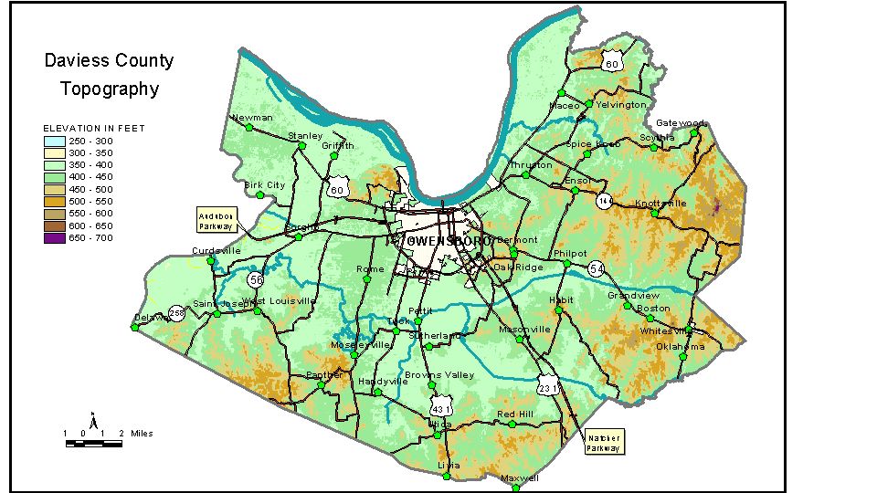
Discussion from McGrain and Currens (1978) Daviess
County is located in the coal field area of northwestern Kentucky.
The Ohio River forms the northern boundary and the Green River marks
part of the western border. The lowest elevations are along these streams.
The normal pool elevation of the Ohio River at the Daviess-Henderson
County line is 347 feet; the normal pool elevation of the Ohio River
at the mouth of Blackford Creek in the northeastern corner of the county
is 358 feet. The elevation of the Green River at the Daviess-Henderson
County line is 349 feet. Broad floodplains are present along these streams,
and the alluvial flats rarely attain elevations as high as 400 feet. Elsewhere in the county the topography is more subdued, with low, rolling
hills and occasional island-like hill masses surrounded by alluviated
valleys. Bon Harbor Hills, a group of hills and ridges surrounded by
lowlands, is a striking example. The highest points on Bon Harbor Hills
is 550 feet, some 150 feet above the valley flats. The elevation of Owensboro, the county seat, at the city hall is 400 feet. Elevations at other communities are Curdsville, 392 feet; Delaware, 392 feet; Knottsville, 558 feet; Maceo, 387 feet; Panther, 470 feet; Philpot, 430 feet; Sutherland, 400 feet; West Louisville, 460 feet; and Whitesville, 462 feet. The 7.5-minute topographic quadrangle maps that cover Daviess County
are shown, by name and by index code (Kentucky Natural Resources and
Environmental Protection Cabinet) on the index
map. Previous--Next--Back to "Groundwater Resources in Kentucky"
|
||