| Topography | ||
|
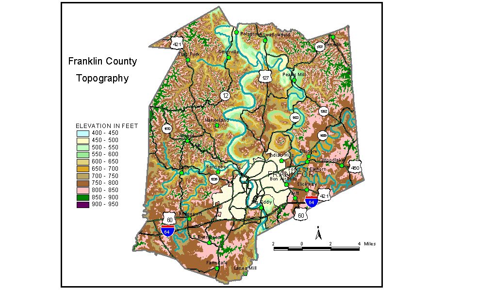
Discussion from McGrain and Currens (1978) Franklin
County, in central Kentucky, occupies parts of both the Inner and
Outer Bluegrass Regions. It is primarily an upland limestone area, fairly
well dissected by normal stream drainage. The topography is rolling
to hilly. Elevations of the higher ridges are commonly between 850 and 900 feet.
The highest point, 930 feet, is on Union Ridge near the eastern edge
of the county. Pea Ridge, approximately 1 mile west of Capital City
Airport, has a maximum elevation of 920 feet, and Dry Ridge, near the
western edge of the county, has a maximum elevation in Franklin County
of 913 feet. A number of abandoned meanders occur along Elkhorn Creek and the Kentucky
River, marking former routes of these streams. Hill-like masses of variable
heights occupy the centers of these former stream-valley loops. Examples
are The Backbone, an abandoned-meander core on Elkhorn Creek with a
maximum elevation of 867 feet, and Fort Hill, an abandoned-meander core
on the Kentucky River in Frankfort with a maximum elevation of 790 feet. The lowest elevation in the county is 455 feet, the normal pool level
of the Kentucky River below Lock and Dam No. 4 at Frankfort. The normal
pool level of the Kentucky River upstream from this dam is 469 feet. The elevation of Frankfort at the city hall is approximately 510 feet; the State Capitol is at 595 feet; and the hills around Frankfort are 800 to 820 feet. Other elevations include Bridgeport, 695 feet; Farmdale, 820 feet; Peaks Mill, 525 feet; Swallowfield, 530 feet; and Switzer, 734 feet. The 7.5-minute topographic quadrangle maps that cover Franklin County
are shown, by name and by index code (Kentucky Natural Resources and
Environmental Protection Cabinet) on the index
map. Previous--Next--Back to "Groundwater Resources in Kentucky"
|
||