| Topography | ||
|
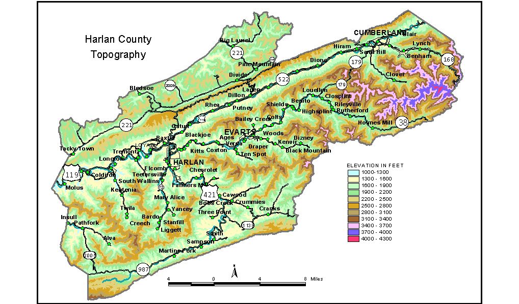
Discussion from McGrain and Currens (1978) Harlan
County, in southeastern Kentucky, is in some of the most rugged
terrain in the Commonwealth. Great mountain ridges cross the county
and are outstanding features of the topography. Valley bottoms are narrow,
but contain about the only flat land in the county. All the communities
are located along the valley bottoms. The highest elevation in the county, and the highest in Kentucky, is found on Black Mountain, a massive, sinuous range lying between Cumberland and Pine Mountains. Elevations on the crest of Black Mountain generally exceed 3,000 feet. The highest elevation recorded on a topographic map in Kentucky is a benchmark at 4,139 feet, approximately 3 1/2 miles south-southeast of Lynch in the eastern part of the county. According to a written communication from R.H. Lyddan, Chief of the Topographic Division of the U.S. Geological Survey, the highest elevation is 4,145 feet, an unmarked point in the area immediately north of the benchmark. Other high elevations are found on Little Black Mountain, 2,600 to
3,600 feet, and Brush Mountain, 2,400 to 2,500 feet. The Cumberland River and its tributaries drain most of Harlan County.
Valley sides are steep. For example, Looney Creek, along which are located
the communities of Benham and Lynch, is 1,800 to 2,200 feet below the
crest of Benham Spur, 1 1/2 miles to the south, and 1,500 to 1,700 feet
below the crest of Looney Ridge, 1 mile to the north. The Cumberland
River is approximately 1,300 to 1,400 feet below the crest of Pine Mountain,
which parallels it 1 1/2 miles to the northwest. The lowest elevation
in the county, approximately 1,070 feet, is at the point where the Cumberland
River leaves the county. All the communities in Harlan County are at elevations above 1,000 feet. The elevation of Harlan, at the courthouse, is 1,197 feet. Other elevations are Alva, 1,425 feet; Benham, 1,602 feet; Caywood, 1,320 feet; Cumberland, 1,440 feet; Evarts, 1,299 feet; Louellen, 1,500 feet; Loyall, 1,165 feet; Lynch, at the high school, 1,800 feet; and Wallins Creek, 1,134 feet. The 7.5-minute topographic quadrangle maps that cover Harlan County
are shown, by name and by index code (Kentucky Natural Resources and
Environmental Protection Cabinet) on the index
map. Previous--Next--Back to "Groundwater Resources in Kentucky"
|
||