|
|
|
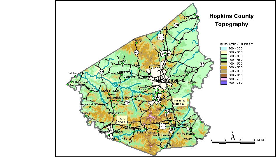
Discussion from McGrain and Currens (1978)
Hopkins
County is in the Western Kentucky coal field. The topography ranges
from nearly flat
along the broad valleys of Green, Pond, and Tradewater Rivers to hilly
in the southern and
central parts of the county. The elevations of the valley flats are
generally between 380 and 400
feet. Gradients of these rivers and some of the tributary streams are
low, and swampy conditions
may be present. The lowest elevation in the county, approximately 345
feet, occurs where Green
River leaves the county at the junction of McLean and Webster Counties,
and where Tradewater
River leaves the county at the junction of Caldwell and Webster Counties.
Hills and ridges range from 100 to 300 feet above the valley floors.
Ridgetop elevations between
500 and 600 feet are common. The highest elevation, 729 feet, a point
on a ridge forming part of
the drainage divide between Pond and Tradewater Rivers, is located approximately
3 miles north
of Saint Charles.
Madisonville is the county seat. The elevation at the intersection
of Center and Main Streets is
470 feet. Elevations of other communities are Ashbyburg, 388 feet; Beulah,
525 feet; Coiltown,
438 feet; Dalton, 405 feet; Dawson Springs, 414 feet; Earlington, 422
feet; Hanson, 433 feet;
jewel City, 385 feet; Mortons Gap, 444 feet; Nebo, 405 feet; Nortonville,
407 feet; Saint Charles,
450 feet; and White Plains, 412 feet.
The 7.5-minute topographic quadrangle maps that cover the county are
shown, by name and by index code (Kentucky Natural Resources and Environmental
Protection Cabinet) on the index
map.
Previous--Next--Back
to "Groundwater Resources in Kentucky"
|