| Topography | ||
|
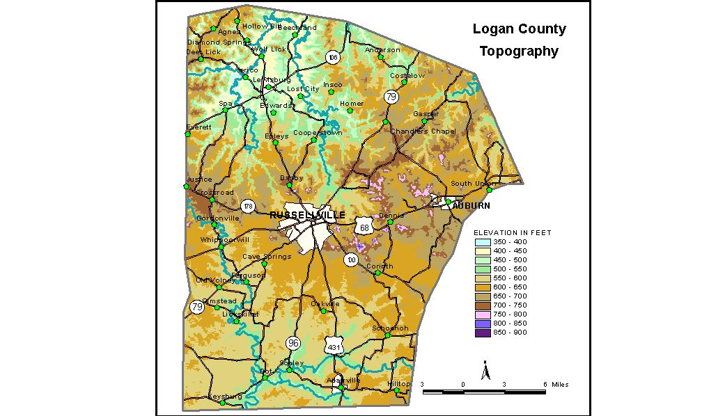
Discussion from McGrain and Currens (1978) Logan
County is in the Mississippian Plateaus area of southwestern Kentucky.
The terrain ranges from gently rolling to hilly, and the county can
be divided topographically into two broad areas. The highest elevations in the county are found in a line of isolated
hills and knobs situated just south of U.S. 68 between Auburn and Russellville.
These are erosion remnants from the Dripping Springs Escarpment, and
many attain elevations in excess of 800 feet. The highest of this group,
and the highest point in the county, is a knob about 3 1/2 miles southeast
of Russellville with an elevation of 868 feet. There are also some high
knobs in the northern part of the county near Beechland. Tan Knob, southeast
of Beechland, has an elevation of 762 feet; Iron Mountain, southwest
of Beechland, is 720 feet. By contrast, the lowest elevation in Logan County is approximately
395 feet, at the point where Mud River leaves the county. Mud River,
which drains the northwestern part of the county, is a slow-flowing,
sluggish stream with a low gradient. The elevation of Lake Malone, in
the northwestern corner of the county, is 450 feet. The elevation of Russellville, the county seat, is 595 feet. Elevations
at other communities are Adairville, 600 feet; Anderson, 637 feet; Auburn,
642 feet; Epleys, 680 feet; Homer, 525 feet; The 7.5-minute topographic quadrangle maps that cover the county are
shown, by name and by index code (Kentucky Natural Resources and Environmental
Protection Cabinet) on the index
map. Previous--Next--Back to "Groundwater Resources in Kentucky"
|
||