| Topography | ||
|
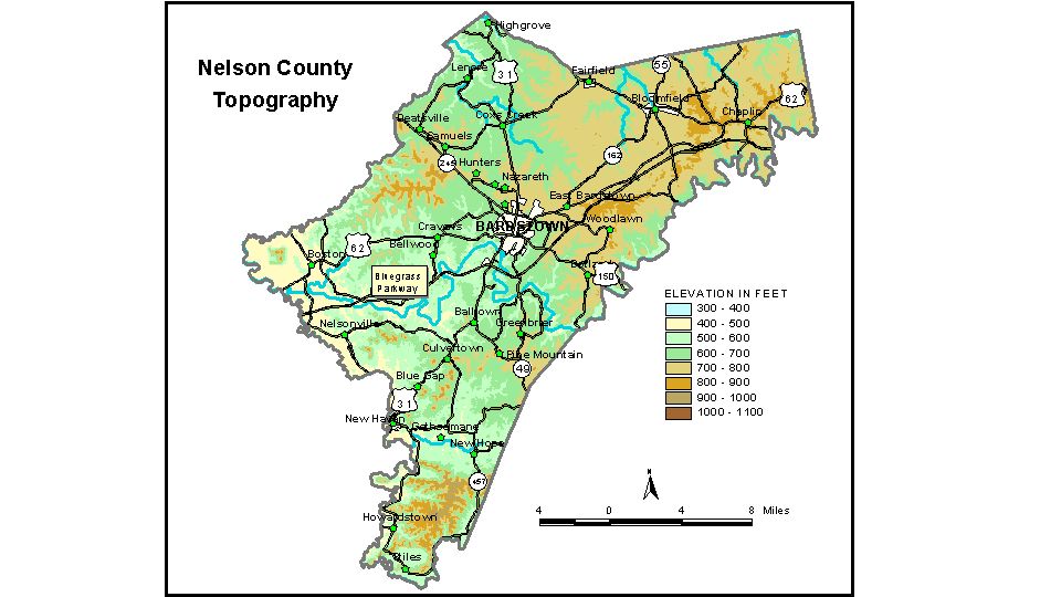
Discussion from McGrain and Currens (1978) Nelson
County includes parts of the Outer Bluegrass Region of central Kentucky
and fringes of The Knobs Region east of Muldraugh Hill (Highland Rim).
The valley of Rolling Fork separates upland masses from the main escarpment
in the southwestern part of the county. Broad, flat areas are present between valleys in the central part of
the county. The tableland dips gently from an elevation of about 750
feet east of Bardstown to about 600 feet west of Bardstown. The most striking topography in the county is found in the western
and southwestern areas. In The Knobs area, conical hills and irregular
land masses rise 300 to 400 feet or more above the surrounding lowland.
Slopes are steep. The highest elevation in the county, 1,090 feet, is
on Rohan Knob, located on the Nelson-Marion County line. Cecil Ridge,
northeast of Howardstown, has a maximum elevation of 1,022 feet, and
Indian Grave Ridge in Knobs State Forest has a maximum elevation of
902 feet. Several knobs northeast of New Haven also attain elevations
in excess of 900 feet. The lowest elevations in the county are along the valley of Rolling
Fork. The lowest point, approximately 390 feet, is where Rolling Fork
leaves the county. The elevation of Bardstown, at the courthouse, is 647 feet. Other elevations are Bloomfield, 657 feet; Boston, 454 feet; Chaplin, 830 feet; Coxs Creek, 700 feet; Cravens, 617 feet; Deatsville, 687 feet; Fairfield, 721 feet; Howardstown, 507 feet; Nelsonville, 473 feet; New Haven, 470 feet; New Hope, 518 feet; Samuels, 677 feet; and Woodlawn, 790 feet. The 7.5-minute topographic quadrangle maps that cover Nelson County
are shown, by name and by index code (Kentucky Natural Resources and
Environmental Protection Cabinet) on the index
map. Previous--Next--Back to "Groundwater Resources in Kentucky"
|
||