| Topography | ||
|
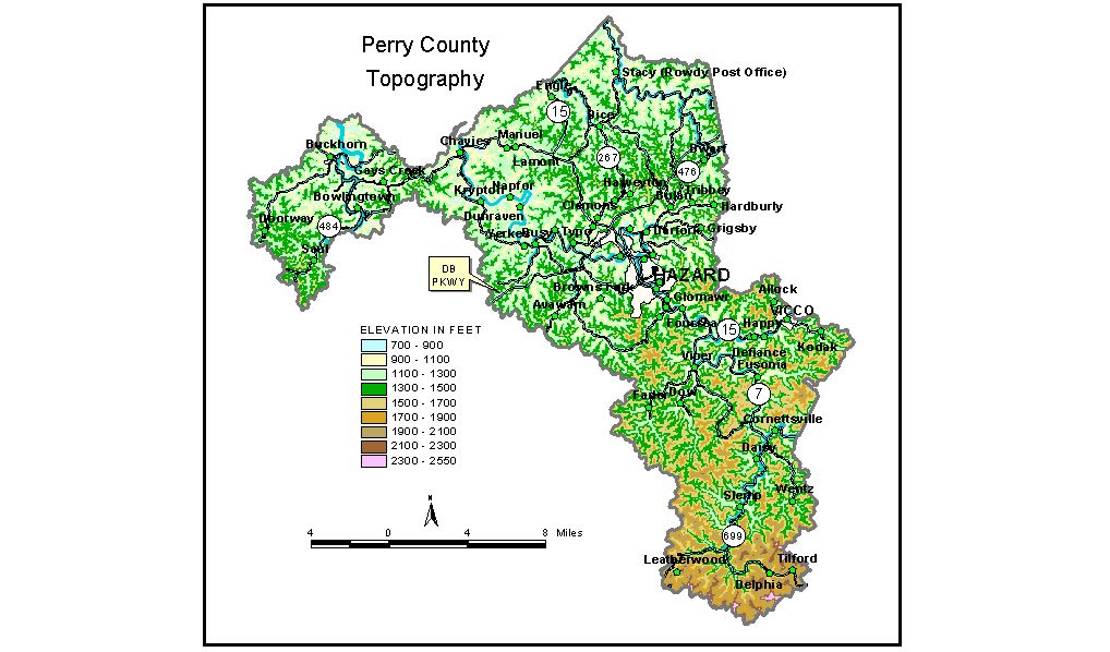
Discussion from McGrain and Currens (1978) Perry County is in the mountainous Eastern Kentucky Coal Field. The area is maturely dissected. Ridges and valleys occupy about equal portions of the landscape. The meandering valleys of the Middle and North Forks of the Kentucky River cross parts of the county and are outstanding topographic features. The principal flat areas in the county and the lowest elevations are found in the valleys of these two streams. The elevation of the Middle Fork of the Kentucky River is approximately 700 feet where it leaves the county, and the elevation of the North Fork is approximately 765 feet where it leaves the county. Buckhorn Lake, a flood-control facility on the Middle Fork, has a normal pool elevation of 757 feet; the elevation of the flood spillway is 820 feet. Upland elevations generally exceed 1,400 feet. Local reliefs of 600 to 800 feet are common. The highest elevations are in the southern extremity of the county, where mountaintop elevations in excess of 2,000 feet are found. The highest elevation, a point 1 1/2 miles southwest of Tilford near the Perry-Letcher County line, is 2,520 feet. All the communities are in valleys. The elevation of Hazard at the courthouse is 880 feet. Elevations at other communities are Buckhorn, 740 feet; Chavies, 805 feet; Cornettsville, 953 feet; Krypton, 806 feet; Leatherwood, 1,600 feet; Tilford, 1,605 feet; and Vicco, 949 feet. The 7.5-minute topographic quadrangle maps that cover the county are shown, by name and by index code (Kentucky Natural Resources and Environmental Protection Cabinet) on the index map. Previous--Next--Back to "Groundwater Resources in Kentucky"
|
||