| Topography | ||
|
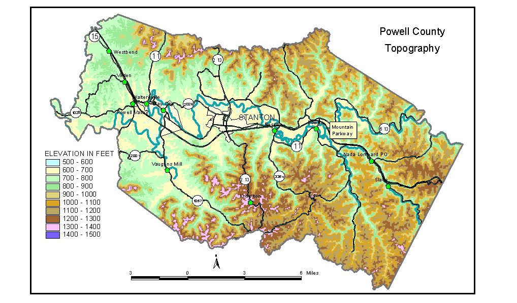
Discussion from McGrain and Currens (1978) Powell County is at the western edge of the Eastern Kentucky Coal Field. The area is a well-dissected upland, being drained principally by the Red River, a tributary of the Kentucky River. Elevations in excess of 1,200 feet and local reliefs of 400 feet or more are common. Part of the famed scenic gorge of the Red River marks the Powell-Menifee County line. Downstream from the gorge the valley widens appreciably and contains the principal areas of flat land in the county. Powell County is characterized by sandstone-capped ridges, steep to precipitous valley walls, and craggy pinnacles. The eastern part of the county lies in the heart of the natural bridge region of Kentucky, an area of magnificent natural sandstone arches. Natural Bridge State Park is located here in one of the most picturesque portions of the Commonwealth. A small area of rolling hills typical of the Outer Bluegrass Region lies southwest of Clay City. Ridgetop elevations are commonly about 800 feet, some 200 above the Red River. The highest elevation in the county is about 1,440 feet. This is found on Pilot Knob, about 2 miles east of Westbend, State Rock, and two other points on or near the Powell-Estill County line south and southwest of Stanton. The lowest elevation, 580 feet, is where the Red River leaves the county. Other elevations of interest are Stanton, the county seat, 659 feet; the lodge at Natural Bridge State Park, 860 feet; top of Natural Bridge, 1,280 feet; Clay City, 621 feet; Nada, 696 feet; Slade, 720 feet; and Westbend, 740 feet. The 7.5-minute topographic quadrangle maps that cover the county are shown, by name and by index code (Kentucky Natural Resources and Environmental Protection Cabinet) on the index map. Previous--Next--Back to "Groundwater Resources in Kentucky"
|
||