| Topography | ||
|
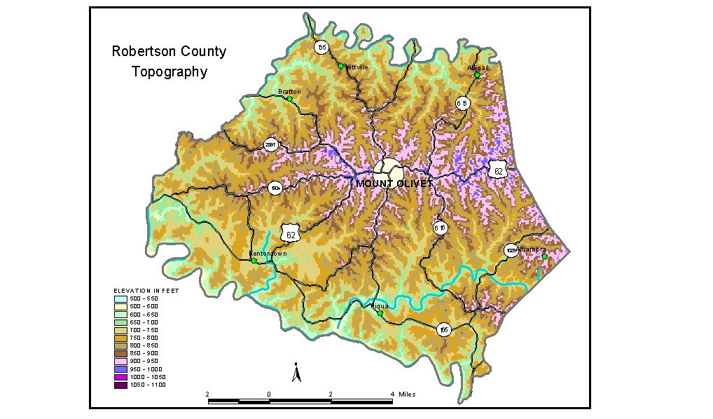
Discussion from McGrain and Currens (1978) Robertson County is in the Outer Bluegrass Region in northern Kentucky. The terrain is hilly. The Licking River, which marks the southern and western boundaries, and the North Fork of the Licking River, which marks the northern boundary, are the most striking topographic features in the county. Ridgetop elevations generally range from 800 to 950 feet. Local relief is generally in excess of 100 feet. The greatest local relief is found along the valley of Licking River, where differences in elevations between the stream and the adjacent hills and ridges may exceed 200 feet. The highest elevation in Robertson County is 1,009 feet, on a ridge adjacent to Ky. 539, 2 miles west-northwest of Mount Olivet. This ridge is part of the drainage divide between the Licking River and the North Fork of the Licking River and contains some of the highest elevations in the county. The lowest elevation, approximately 550 feet, is the point where Licking River leaves the county. The North Fork of the Licking River leaves the county at an elevation of about 605 feet. The elevation of Mount Olivet, the county seat, is 958 feet. The entrance to Blue Licks Battlefield State Park is at 692 feet. The elevation of Kentontown is 733 feet, and Piqua is at 680 feet. The 7.5-minute topographic quadrangle maps that cover the county are shown, by name and by index code (Kentucky Natural Resources and Environmental Protection Cabinet) on the index map. Previous--Next--Back to "Groundwater Resources in Kentucky"
|
||