| Topography | ||
|
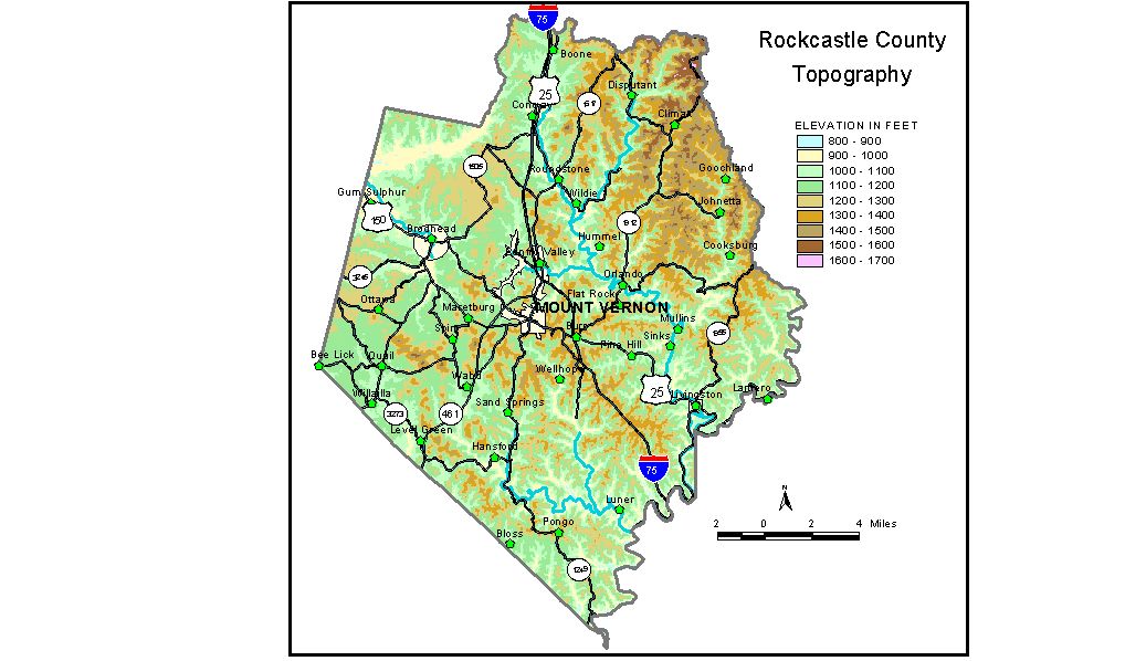
Discussion from McGrain and Currens (1978) The area covered by Rockcastle County includes parts of both the Mississippian Plateaus and the Eastern Kentucky Coal Field physiographic regions. The terrain is generally hilly; locally the topography can be described as rugged. A conspicuous tableland is present between Brodhead and Renfro Valley. This topography of low local relief contrasts strikingly with the hill country to the north and the almost mountainous terrain to the south. The elevation of the tableland is approximately 1,200 feet. Karst features such as sinkholes and streamless valleys may be found at scattered points in the central part of the county. The highest elevation in the county, 1,638 feet, is on a ridge near the Rockcastle-Jackson County line in the northeast corner of the county, not far from the top of the Cumberland Escarpment. Valleys in this area are incised as much as 500 feet below the highest ridges and hills. The highest hills and ridges in the Eastern Kentucky Coal Field area of eastern and southeastern Rockcastle County are commonly 1,200 to 1,400 feet high. Differences in elevations between the valley bottoms and adjacent uplands are 400 feet or more in many places. The valley sides are steep, and precipitous cliffs may be present. The Rockcastle River marks the southeastern border of the county. The lowest elevation in the county, approximately 810 feet, is the point where the Rockcastle River passes the extreme southern tip of the county. The elevation of Dix River, where it leaves the northwestern part of the county, is approximately 875 feet. Mount Vernon is the county seat; the elevation at the courthouse is about 1,170 feet. The elevation of Boone Gap, at the Rockcastle-Madison County line, is 1,150 feet. Other elevations are Brodhead, 940 feet; Lake Linville spillway, 969 feet; Livingston, 889 feet; Maretburg, 1,149 feet; Renfro Valley, 950 feet; and Wildie, 929 feet. The 7.5-minute topographic quadrangle maps that cover the county are shown, by name and by index code (Kentucky Natural Resources and Environmental Protection Cabinet) on the index map. Previous--Next--Back to "Groundwater Resources in Kentucky"
|
||