| Topography | ||
|
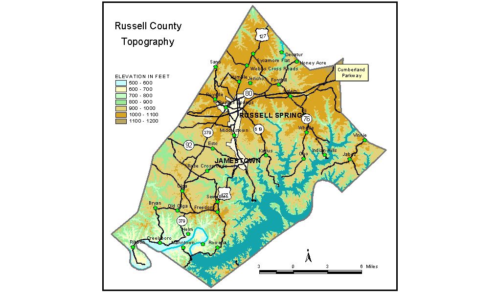
Discussion from McGrain and Currens (1978) Russell County is in the Mississippian Plateaus region of south-central Kentucky. The area is a moderately to well-dissected plateau, and the resulting terrain is rolling to hilly. Locally, particularly in the vicinity of U.S. 127 north of Russell Springs, ridges are wider and are nearly flat topped. Elevations on the plateau range from 900 feet in the southwest to 1,100 feet in the northeastern corner. The highest point in the county appears to be 1,140 feet, on Roytown Ridge in the northeastern corner of the county. Local reliefs of 100 to 200 feet are common throughout the county. The greatest local relief is found along the Cumberland River. The Cumberland River and Lake Cumberland are along or near the southern border of the county. The normal pool level of Lake Cumberland is 723 feet. The elevation of the Cumberland River below Wolf Creek Dam is approximately 550 feet. The lowest elevation in Russell County is approximately 530 feet, where the river leaves the county. The uplands adjacent to the river and lake have elevations of 900 to 1,000 feet. The elevation of Jamestown, the county seat, is 970 feet. Other elevations are Creelsboro, 613 feet; Eli, 1,015 feet; Freedom, 1,034 feet; Jabez, 1,058 feet; and Russell Springs, 1,090 feet. The 7.5-minute topographic quadrangle maps that cover the county are shown, by name and by index code (Kentucky Natural Resources and Environmental Protection Cabinet) on the index map. Previous--Next--Back to "Groundwater Resources in Kentucky"
|
||