| Topography | ||
|
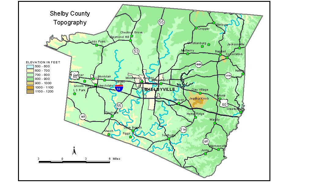
Discussion from McGrain and Currens (1978) Shelby County is in the Outer Bluegrass Region of north-central Kentucky. The topography is rolling to hilly, and local reliefs of 100 feet are common throughout most of the area. Elevations generally range from 750 feet in the west to 900 feet in the east and north. An exception is Jeptha Knob, a mass of irregular hills 1 mile south of Clay Village, which rises some 300 feet above the surrounding terrain. The highest point on Jeptha Knob, and the highest elevation in Shelby County, is 1,188 feet. Brashears and Guist Creeks are the principal streams in the county. They have carved valleys approximately 100 feet below the adjacent upland. Brashears Creek leaves the southern part of the county at an elevation of approximately 565 feet; Guist Creek, at 550 feet, has the lowest elevation in the county. The spillway elevation of Guist Creek Lake east of Shelbyville is 760 feet. The elevation of Shelbyville, the county seat, is 760 feet. Elevations at other communities are Bagdad, 912 feet; Christianburg, 904 feet; Clay Village, 908 feet; Elmburg, 880 feet; Finchville, 760 feet; Graefenburg, 738 feet; Harrisonville, 889 feet; Lincoln Ridge, 770 feet; Montclair, 773 feet; Mount Eden, on the Shelby-Spencer County line, 841 feet; Peytona, 922 feet; Southville, 809 feet; and Todds Point, 820 feet. The 7.5-minute topographic quadrangle maps that cover the county are shown, by name and by index code (Kentucky Natural Resources and Environmental Protection Cabinet) on the index map. Previous--Next--Back to "Groundwater Resources in Kentucky"
|
||