| Topography | ||
|
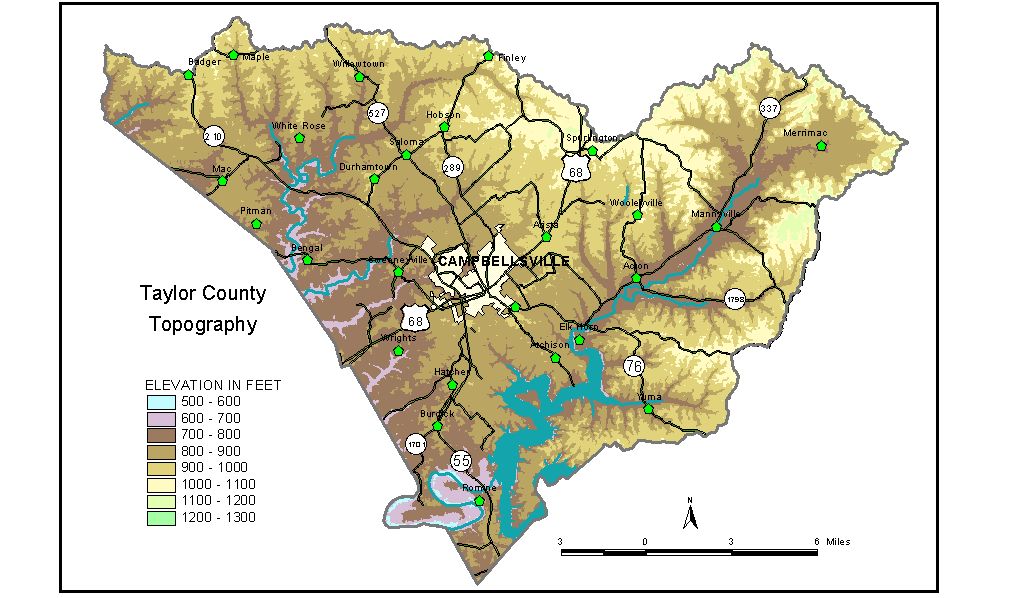
Discussion from McGrain and Currens (1978) Taylor County is in the Mississippian Plateaus Region of south-central Kentucky. The area is a dissected plateau varying from gently rolling to hilly. A small sinkhole plain is present in the northwestern part of the county, near the headwaters of Brush and Little Brush Creeks. Broad, flat-topped ridges characterize the central part of the county, but elsewhere the topography is generally rolling to hilly. The valleys of the Green River and some of its tributaries are relatively broad and flat. The lowest elevation is 570 feet, where the Green River leaves the county. Green River Lake, a flood-control facility on the Green River, has a normal pool elevation of 675 feet and a maximum flood pool elevation of 713 feet. Highest elevations in the county are along the drainage divide between the Green and Salt Rivers. Elevations in excess of 1,000 feet are common here. This divide also marks the Taylor-Marion County line and follows, in part, Muldraugh Hill (Highland Rim Escarpment). The highest point is 1,200 feet, on a ridge on the Taylor-Marion County line near the junction with Casey County. Bass Ridge on the Taylor-Casey County line also has elevations between 1,000 and 1,100 feet. The elevation of Campbellsville, at the courthouse, is 810 feet. Elevations at other communities are Mannsville, 733 feet; Saloma, 900 feet; and Spurlington, 1,000 feet. The elevation of the spillway at Sportsman Club Lake is 838 feet. The 7.5-minute topographic quadrangle maps that cover the county are shown, by name and by index code (Kentucky Natural Resources and Environmental Protection Cabinet) on the index map. Previous--Next--Back to "Groundwater Resources in Kentucky"
|
||