| Topography | ||
|
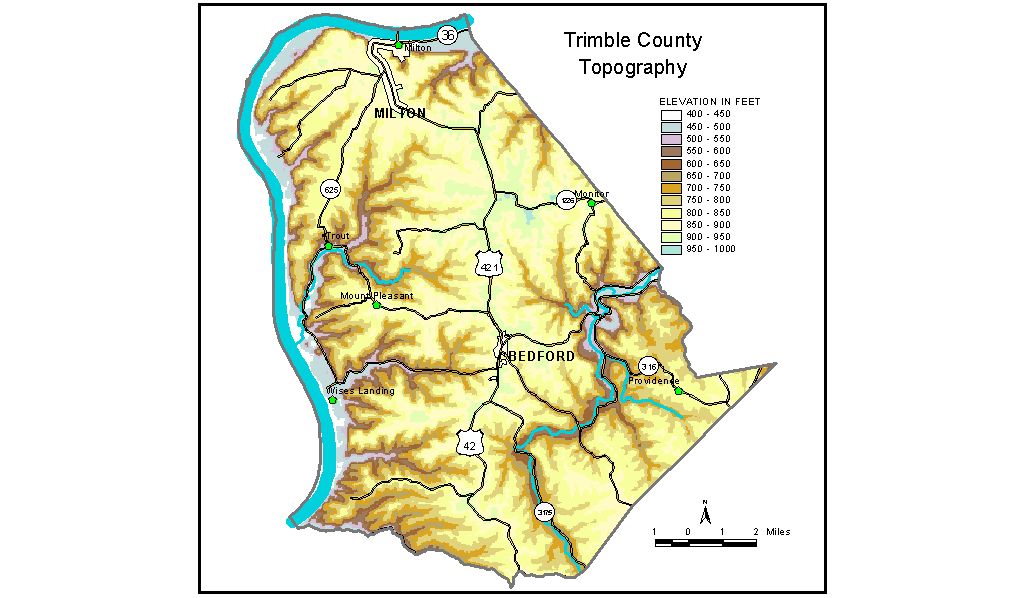
Discussion from McGrain and Currens (1978) Trimble County is in the Outer Bluegrass Region of north-central Kentucky. The Ohio River marks the northern and western borders. The normal pool elevation of the Ohio, 420 feet, is the lowest elevation in the county. Adjacent bluffs rise abruptly 300 feet above the river and mark the sites of the greatest local relief. Where flats are present along the Ohio River, they are at an elevation of approximately 470 feet. The area is a well-dissected upland. It is hilly, and steep slopes are common. Local reliefs of 150 to 200 feet are present. A few small sinkholes may be found near the tips of the larger ridges. Upland elevations are 750 to 800 feet in the west; some are more than 900 feet in the central part of the county; and they are generally about 850 feet in the east. Most of the higher elevations are along or near a flat-topped ridge near the center of the county, which is a drainage divide between the Little Kentucky River on the east and minor tributary streams to the Ohio River on the west. The highest elevation in the county, 970 feet, is on Fishers Ridge south of Ky. 1226, about 3 3/4 miles north-northeast of Bedford. The Little Kentucky River crosses the southeastern part of the county and has carved a valley 200 to 250 feet below the adjacent upland. Bunker Hill, a core of an abandoned meander of the Little Kentucky River, has an elevation of 686 feet and stands 186 feet above the surrounding valley. The elevation of Bedford, the county seat, is 910 feet. Elevations at other communities are Milton, 468 feet; Monitor, 924 feet; Mt. Pleasant, 859 feet; and Wises Landing, 470 feet. The 7.5-minute topographic quadrangle maps that cover the county are shown, by name and by index code (Kentucky Natural Resources and Environmental Protection Cabinet) on the index map. Previous--Next--Back to "Groundwater Resources in Kentucky"
|
||