| Karst | ||
|
By James C. Currens, Kentucky Geological Survey A karst landscape has sinkholes, sinking streams, caves, and springs. Kentucky is one of the most famous karst areas of the world. Much of the state's beautiful scenery, particularly the horse farms of the Inner Bluegrass, results from the development of karst landscape. Karst underlies regions of major economic importance to the state. Many of Kentucky's cities, including Frankfort, Louisville, Lexington, Bowling Green, Elizabethtown, Munfordville, Hopkinsville, Russellville, Princeton, Lawrenceburg, Georgetown, Winchester, Paris, Somerset, Versailles, and Nicholasville, are partly or entirely underlain by karst. Springs and wells in karst areas supply water to thousands of homes. Much of Kentucky's prime farmland is underlain by karst. A substantial portion of the Daniel Boone National Forest, with its important recreational and timber resources, is underlain by karst. Caves also provide recreational opportunities and contain unique ecosystems. Mammoth Cave, with over 350 miles of passages, is the longest surveyed cave in the world. Two other caves in the state are over 30 miles long, and 10 Kentucky caves are among the 50 longest in the United States. Although maps that show in detail where the karst terrain of Kentucky occurs have never been made, the areas underlain by rocks on which karst can develop have been mapped. The 1:500,000-scale geologic map (Noger, 1988) can be used to estimate the percentage of karst terrain in the state. Ninety-two of Kentucky's 120 counties contain at least some areas of karst. About 40 percent of the state is underlain by rocks with the potential for at least some karst development (recognizable on topographic maps), and 20 percent of the state has well-developed karst features. Karst RegionsThe karst of Kentucky occurs in five principal regions, but also in many scattered locations.
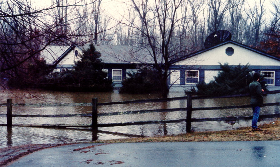
The last major karst area lies along the crest of Pine Mountain in southeastern Kentucky, where geologic forces have thrust the limestone from deep beneath the coal field to the surface. No communities occupy this karst area, but it is a significant recreational and ecological resource, and springs draining from it are important water supplies. Karst terrain affects the lives of many Kentuckians every day. Most people don't realize they are affected because the costs are hidden in the form of higher taxes and increased cost of living. Often enough, the consequences of living in a karst terrain directly affect people's lives. Of vital concern is protection of groundwater resources. For example, many communities in Kentucky were established near karst springs to take advantage of the reliable water supply. Because of pollution, most of these town springs have long since been abandoned as water supplies. Factories and homes built over filled sinkholes may be damaged as the fill is transported out of the sinkhole and the soil cover collapses. Also, structures built in sinkholes are often vulnerable to flood damage.
Flooding in a karst area. Features of a Karst LandscapeThe term "karst" is derived from a Slavic word that means barren, stony ground. It is also the name of a region in modern Slovenia near the border with Italy that is well known for its sinkholes and springs. The name has been adopted by geologists as the term for all such terrain. A karst landscape most commonly develops on limestone but can develop on several types of rocks, such as dolomite, gypsum, and salt. The karst terrains of Kentucky are mostly on limestone and formed over hundreds of thousands of years. As water moves underground, from hilltops toward a stream through tiny fractures in the limestone bedrock, the rock is slowly dissolved away by weak acids found naturally in rain and soil water. An aquifer is any body of rock from which important quantities of drinkable water may be produced. Springs are sites where groundwater emerges from an aquifer to become surface water. Springs occur along creeks and rivers where the water table meets the land surface. They also occur where rocks that do not allow water to flow easily, such as shale, underlie or have been faulted against permeable rock. The impermeable rock blocks the flow of the groundwater, forcing it to the surface. Karst springs occur where the groundwater flow has concentrated to dissolve a conduit or cave in soluble rock. The groundwater basin of a karst spring collects drainage from all the sinkholes and sinking streams in its drainage area. The water flowing from each sinkhole joins together underground to form ever-increasing flow in successively larger passages, which discharge at the spring. Karst springs (also known as "cave springs") can have large openings and discharge very large volumes of water. The soil cover, narrow fractures, small conduits, and larger cave passages collectively form a karst aquifer. A sinkhole is any depression in the surface of the ground into which rainfall is drained. Karst sinkholes form when a fracture in the limestone bedrock is preferentially enlarged. Sinkholes form in two ways. In the first way, the bedrock roof of a cave becomes too thin to support the weight of the bedrock and the soil material above it. The cave roof then collapses, forming a collapse sinkhole. Bedrock collapse is rare, and the least likely way a sinkhole can form, although it is commonly assumed to form all sinkholes. The second way sinkholes form is much more common and much less dramatic. As the rock is dissolved and carried away underground, the soil gently slumps or erodes into a dissolution sinkhole. Once the underlying conduits become large enough, insoluble soil and rock particles are carried away too. Dissolution sinkholes form over long periods of time, with occasional episodes of soil or cover collapse. All of the dissolved limestone and soil particles eroded from the bedrock to form a sinkhole pass through the sinkhole's "throat" or outlet. The throat of a sinkhole is sometimes visible, but is commonly roofed by soil and broken rock and can be partly or completely filled with rubble. This opening can vary from a few inches in diameter to many feet. Normally, water flows out of the sinkhole throat to a conduit that drains to a spring. When sinkhole throats are totally blocked and little water can flow out, a "sinkhole pond" may form, a common sight in the Pennyroyal. Sinkhole ponds are temporary features and last only as long as the throat is tightly plugged. Swallow holes are points along streams and in sinkholes where surface flow is lost to underground conduits. Swallow holes range in diameter from a few inches to tens of feet, and some are also cave entrances. Swallow holes are often large enough to allow large objects such as tree limbs and cobble-size stones to be transported underground. This means that waste dumped into sinkholes can easily reach underground streams. It is not uncommon for discarded automobile tires and home appliances to be found deep within caves with flowing streams. Likewise, sewage, paint, motor oil, pesticides, and other pollutants are not filtered from water entering a karst aquifer. A karst window is a special type of sinkhole that gives us a view, or window, into the karst aquifer. A karst window has a spring on one end, a surface-flowing stream across its bottom, and a swallow hole at the other end. The stream is typically at the top of the water table. Karst windows develop by both dissolution and collapse of the bedrock. Many karst windows originated as collapse sinkholes. Karst locations are shown on a map of karst in Trimble County. More information on karst is available on the KGS Web site. Previous--Next--Back to "Groundwater Resources in Kentucky"
|
||