| Topography | ||
|
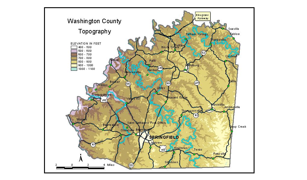
Discussion from McGrain and Currens (1978) The topography of Washington County is typical of the Outer Bluegrass Region of central Kentucky. It is a well-dissected upland of irregular hills and ridges. Very little flat land occurs except in he valleys of the larger streams. An exception is the flat-topped ridge that forms the divide between Cartwright and Hardins Creeks and in the Mooresville area of the county. Ridgetop elevations range from 1,000 feet in the southeastern corner of the county to 800 feet in the northwestern corner. Differences in elevations between valley bottoms and ridgetops are generally 100 to 150 feet. The highest elevation in the county, 1,020 feet, is on a ridge south of U.S. 150 near the southeastern corner of the county. The lowest elevation, approximately 475 feet, is found at the confluence of Brush Fork and Hardins Creek at the northwestern corner of the county. The elevation of Springfield, the county seat, is 733 feet. Other elevations include Cardwell, 847 feet; Fredericktown, 520 feet; Mackville, 917 feet; Maud, 558 feet; Mooresville, 768 feet; Texas, 897 feet; and Willisburg, 857 feet. The elevation of Willisburg Lake is 720 feet. The 7.5-minute topographic quadrangle maps that cover the county are shown, by name and by index code (Kentucky Natural Resources and Environmental Protection Cabinet) on the index map. Previous--Next--Back to "Groundwater Resources in Kentucky"
|
||