| Topography | ||
|
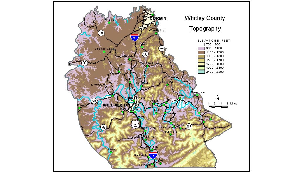
Discussion from McGrain and Currens (1978) Whitley County is on the southern border of the Eastern Kentucky Coal Field. It is a well-dissected upland with a hilly to mountainous terrain. The topography in the northern part of the county is more subdued than that normally found in the Eastern Kentucky Coal Field. Broad, gently rolling to nearly flat-topped ridges at elevations of approximately 1,200 feet are common here. Many of the headwaters streams have shallow valleys, and the area has a distinct plateau-like appearance. The southern part of Whitley County is mountainous. Pine Mountain, the highest and most striking topographic feature in the county, crosses the southeastern part of the county from southwest to northeast. This linear mountain ridge extends almost 10 3/4 miles across Whitley County, 5 miles of which mark the Whitley-Bell County boundary. Elevations in excess of 2,000 feet are common along the spine-like crest. The highest elevation in the county, 2,220 feet, is a peak on Pine Mountain located near the eastern extremity of the county. A number of other mountains in the southern part of Whitley County also attain elevations in excess of 2,000 feet. Among them are Bear Wallow Mountain, 2,188 feet; Jellico Mountain, 2,160 feet; Round Mountain, 2,011 feet; Ryans Creek Mountain, 2,040 feet; Vanderpool Mountain, 2,165 feet; and Wolf Knob, 2,140 feet. The Cumberland River crosses the county from east to west and then flows northward, marking the boundary between Whitley and McCreary Counties. This part of the river occupies a narrow, rocky gorge some 400 feet deep, and descends rapidly over a series of shoals, rapids, and falls. Cumberland Falls, which is located here, is the site of one of Kentucky's oldest and most scenic state parks. The lowest elevation in the county, 723 feet, is the normal pool level of Lake Cumberland at the north edge of the county. Laurel River Lake impounds waters of Laurel River 2.3 miles above its confluence with the Cumberland River. The conservation pool has an elevation of 982 feet; elevation of the power pool is 1,018.5 feet. The elevation of Williamsburg, the county seat, is 961 feet. Other elevations include Corbin, at the city hall, 1,090 feet; Emlyn, 971 feet; Rockholds, 986 feet; Saxton, 968 feet; Wofford, 936 feet; Woodbine, 1,120 feet; and Dupont Lodge at Cumberland Falls State Park, approximately 1,090 feet. The 7.5-minute topographic quadrangle maps that cover the county are shown, by name and by index code (Kentucky Natural Resources and Environmental Protection Cabinet) on the index map. Previous--Next--Back to "Groundwater Resources in Kentucky"
|
||