
The Kentucky Geological Survey has archived this material, meaning (1) it is for reference, research, or recordkeeping; (2) it was created before April 24, 2026; (3) and the material has not been changed or altered since being archived. Please refer to our KGS Accessibility page for more information.
KGS Home > Oil and Gas
FAQ: What is the Carter coordinate system?
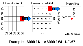 The Carter coordinate system is a land
grid, based on latitude and longitude, used to locate oil and gas well data in Kentucky. The system was developed by the Carter Oil Company to mimic the township and range location system in areas
that had not been surveyed. The State is divided into a regular grid with each cell (or "quad") being five minutes of latitude by five minutes of longitude. These quads are assigned letters
(equivalent of the township) beginning with "A" in the south and increasing through "Z" and "AA" to "GG" northward. The quads are assigned numbers (equivalent of the range) beginning with zero (0) in
the west and increasing to 92 in the east. Each five-minute by five-minute quad is further subdivided into 25 one-minute by one-minute sections. Within the one-minute section, the location is
pinpointed by specifying the distance from an adjacent pair of one-minute section boundaries to the well. The Carter coordinate is written by specifying a pair of footages from the one-minute section
boundaries and the reference boundary (north, south, east, or west) for each, the one-minute section number, the five-minute quad letter, and the five-minute quad number. A Carter coordinate and
topographic index map of Kentucky is available by request, contact the Public Information Center (Publication Sales).
The Carter coordinate system is a land
grid, based on latitude and longitude, used to locate oil and gas well data in Kentucky. The system was developed by the Carter Oil Company to mimic the township and range location system in areas
that had not been surveyed. The State is divided into a regular grid with each cell (or "quad") being five minutes of latitude by five minutes of longitude. These quads are assigned letters
(equivalent of the township) beginning with "A" in the south and increasing through "Z" and "AA" to "GG" northward. The quads are assigned numbers (equivalent of the range) beginning with zero (0) in
the west and increasing to 92 in the east. Each five-minute by five-minute quad is further subdivided into 25 one-minute by one-minute sections. Within the one-minute section, the location is
pinpointed by specifying the distance from an adjacent pair of one-minute section boundaries to the well. The Carter coordinate is written by specifying a pair of footages from the one-minute section
boundaries and the reference boundary (north, south, east, or west) for each, the one-minute section number, the five-minute quad letter, and the five-minute quad number. A Carter coordinate and
topographic index map of Kentucky is available by request, contact the Public Information Center (Publication Sales).
A Carter coordinate location is defined only for the North American Datum of 1927 (NAD27). If you use the KGS Coordinate Conversion Tool to convert a NAD83 location to a Carter coordinate, the output will be NAD27 only.
I have a Carter Coordinate and want to convert it to latitude and longitude.
Links: