
KGS Home > Geology of Kentucky
Eastport region, Dale Hollow Lake, TN
Location: Take TN route 52 east from Livingston, TN. From Alpine, TN continue east on route 52 for about 7.3 miles. Turn north onto Eastport Road and continue about 2.6 miles to the Eastport dock. From the dock travel by boat southeast along the lake for about 1/3 mile and then turn northeast along the Obey River (lake) channel to the northeast and the mound localities.
Latitudes/longitudes: Locality 1 is at 36.44910 N, 85.10560 W; locality 3 is at 36.45400N, 85.08440 W. Both locations are on the Alpine 7.5-minute geologic quadrangle map. The map can be ordered from the Tennessee Division of Geology at www.state.tn.us/environment/tdg/
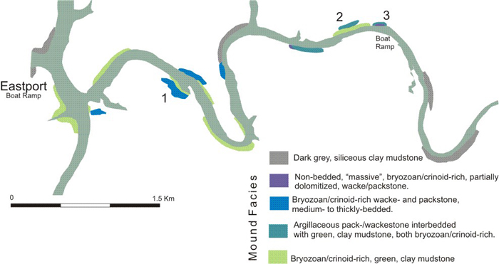
Figure 1. Fort Payne Formation exposures along Dale Hollow Lake
in the vicinity of the Eastport boat dock. Locations 1, 2, and 3 are discussed below.
Description. These shoreline outcrops of Fort Payne facies are accessible only by boat; the exposures are significantly more extensive during the fall when lake levels are at a minimum. In this relatively small area various mound facies and the post-mound, gray, clay mudstone occur at essentially the same topographic, and hence stratigraphic, level. This geographic relationship supports the interpretation that the mounds stood in topographic relief and were then buried by the gray, clay mudstone. Furthermore, the discontinuous distribution and the convex-upward stratal patterns of the green, fossiliferous clay mudstone argue that local deposition of both clay and organic components resulted in the upbuilding of geographically distinct mounds. These initial mounds were then capped by various carbonate facies.
Eastport region, locality 1
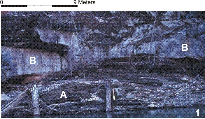
Figure 2. Outcrop of the Fort Payne Formation along Dale Hollow Lake at location 1 in Figure 1.
Bryozoan/crinoid-rich, green, clay mudstone facies (A) overlies carbonates (B). Note paddle for scale.
This outcrop well illustrates the convex stratal geometry commonly present in the bryozoan/crinoid-rich, green, clay mudstone facies (A in Figure 2). This geometry indicates vertical accretion or upbuilding by means of suspension-settling deposition of clay and the in situ production of carbonate skeletal material. Deposition of the fossiliferous, green clay mudstone produced the initial topographic relief of these mounds. Subsurface data in this immediate area indicates that the Chattanooga Shale is approximately 14 meters below lake level. The white B in Figure 2 marks the thickly bedded to "massive", bryozoan/crinoid-rich, wacke/packstone facies, which serves as the capping unit for this mound. The contact between the two facies is sharp (Figs. 2-3).
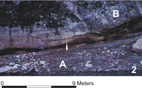
Figure 3. The exposure at location 1 illustrates the sharp, abrupt contact
between the green shale facies (A) and overlying carbonates (B). Note paddle for scale.
Eastport region, locality 2
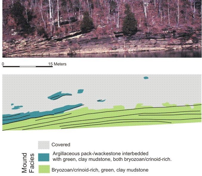
Figure 4. Image and interpretation of Fort Payne mound at location 2 in Figure 1.
This outcrop illustrates the convex stratal geometry commonly present in the bryozoan/crinoid-rich, green, clay mudstone facies. This geometry indicates vertical accretion or upbuilding by means of suspension-settling deposition of clay and the in situ production of carbonate skeletal material. Deposition of the fossiliferous, green clay mudstone (shaded light green) produced the initial topographic relief of these mounds. The stratal geometry of the overlying heterolithic unit (shaded blue-green) is concordant with the upper surface of the fossiliferous, green, clay mudstone. This concordance suggests that suspension settling of clay alternating with in situ production of carbonate skeletal material essentially draped over the original topographic relief and maintained it's basic geometry. Lateral transport either across or off the mound was not a significant process during the deposition of this succeeding facies. Subsurface data in this immediate area indicates that the Chattanooga Shale is approximately 14 meters below lake level.
Eastport region, locality 3.
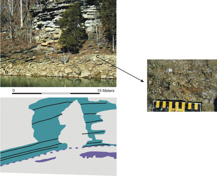
Figure 5. Image and interpretation of Fort Payne mound at location 2 in Figure 1,
with a detailed image of the "massive" facies. In the detailed image, C=crinoid, D=dolomitized region, M=micritic mass.
This is the best Dale Hollow Lake exposure of the non-bedded, "massive", bryozoan/crinoid-rich, wacke/packstone facies (B, shaded purple), which here has been extensively dolomitized. The contact with the overlying heterolithic facies (shaded blue-green, A), consisting of green, clay mudstone and bryozoan/crinoid-rich, argillaceous, wacke/packstone, is sharp. The stratal geometry of the heterolithic facies is concordant with the upper surface of the underlying non-bedded unit. This concordance suggests that suspension settling of clay alternated with in situ production of carbonate skeletal material maintained the original geometry; lateral transport was not a significant process during the deposition of the heterolithic facies. Subsurface data in this immediate area indicates that the Chattanooga Shale is approximately 14 meters below lake level.
Back to Field trip in the Dale Hollow region
Back to top of Geology of the Fort Payne Formation