
The Kentucky Geological Survey has archived this material, meaning (1) it is for reference, research, or recordkeeping; (2) it was created before April 24, 2026; (3) and the material has not been changed or altered since being archived. Please refer to our KGS Accessibility page for more information.
KGS Home > Geology of Kentucky
Cove Creek mound, Dale Hollow Lake, TN
Location: This Fort Payne mud mound is best reached by boat from the Sunset boat dock, located where TN 52 crosses Dale Hollow Lake. Travel northwest from the boat dock along the lake for approximately 5.0 miles to Cove Creek (Fig. 1).
Latitude/longitude: 36.55110 N, 85.215150 W, on the Byrdstown 7.5-minute geologic quadrangle map.The map can be ordered from the Tennessee Division of Geology at www.state.tn.us/environment/tdg/
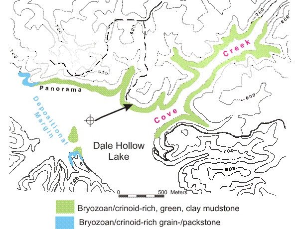
Figure 1. Location of bryozoan- and crinoid-rich mud mound facies along Cove Creek, Dale Hollow Lake.
Description: The exposures along Cove Creek are illustrated in a panorama (Fig. 2) and then parts of the the panorama (A, B, C) are described in more detail (Figs. 3-4).
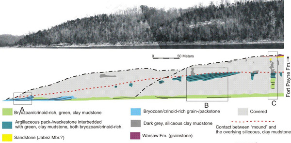
Figure 2. Image and interpretive diagram of the Cove Creek shoreline
showing exposures
of the Fort Payne and overlying Warsaw Formations.
The location is labeled "panorama" on the preceding map.
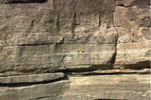
Figure 3. Sediment gravity-flow deposit along Cove Creek at inset A (box) in Figure 2.
Sediment gravity-flow deposit along Cove Creek show original depositional dip, which is approximately 10 degrees, up the mound margin, to the east. These beds are primarily planar laminated and are interpreted to be Tb (Bouma) in origin. The white A marks an interbed of green, fossiliferous clay mudstone. The black B marks the contact between the sediment gravity- flow grainstones and the underlying green mudstone at this point on the margin of the mound. The black C marks a well-exposed planar-laminated unit (Figure 4).
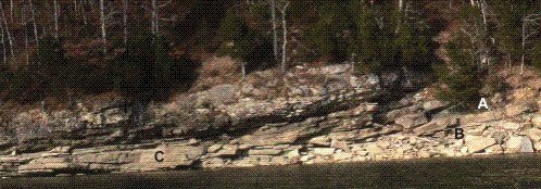
Figure 4. Planar laminations are characteristic of the sediment gravity-flow grainstones
that occur on the depositional margin of this mound, location C in Figure 3 (location A in panorama, Fig. 2).
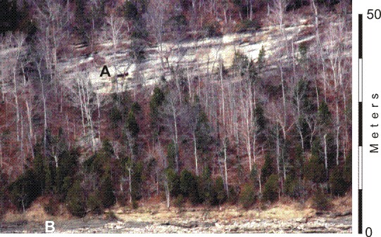
Figure 5. View of bedding at location B in the Cove Creek panorama (Fig. 2).
Inclined bedding characterizes the heterolithic argillaceous, pack-/wackestone and green, clay mudstone (Black A in Figure 5). Both facies are crinoid- and bryozoan-rich. The white B in Figure 5 identifies the green, crinoid- and bryozoan-rich, clay mudstone. The inclined, heterolithic unit is directly overlain by dark gray, siliceous, clay mudstone. This contact is interpreted to be the top of the mound. The Cove Creek mound stood at least 50 meters above the sea floor.
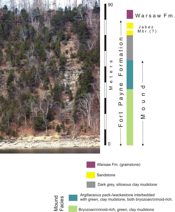
Figure 6. Stratigraphic section at the Log Chute (location C on Figure 2), Cove Creek mound, Dale Hollow Lake, TN.
Back to Field trip in the Dale Hollow region
Back to top of Geology of the Fort Payne Formation