
KGS Home > Geology of Kentucky
Eagle Creek mound, Dale Hollow Lake, TN
Location:
From the intersection of Bradford Hicks Drive and TN 111 on the north side of Livingston, Tennessee travel north and then east on TN 111 for about 4.9 miles to the Monroe, Tennessee post office. Continue east on 111 past the post office for 0.5 miles and turn left (north) onto Jaybird road. (Note: Jaybird Road is shown on some paper maps as Big Eagle Creek road or TN 294). Proceed north on Jaybird road for 2.7 miles until the road enters a wooded area and descends into the valley of Big Eagle Creek, a tributary to Dale Hollow Lake. Just before crossing Big Eagle Creek, and immediately before a metal guard rail, turn left onto a very poor gravel trail that parallels Big Eagle Creek. Proceed about 0.2 miles to the Eagle Creek mound, which is located on the north side of Big Eagle Creek at the northwest end of a meander loop.
Latitude/longitude:
36.47910 N, 85.24130 W, on the Alpine 7.5-minute geologic quadrangle map. The map can be ordered from the Tennessee Division of Geology at www.state.tn.us/environment/tdg/
Description:
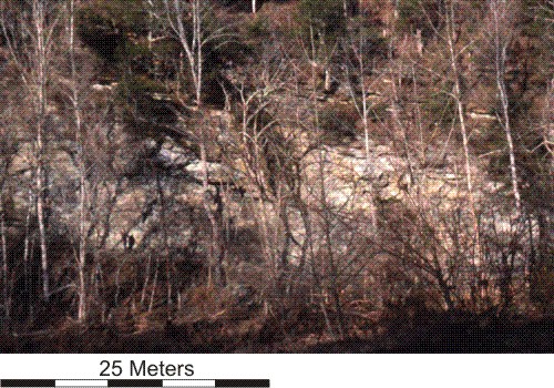
Inclined flanking and/or capping unit of medium to thickly bedded, bryozoan/crinoid-rich, pack- and wackestones. A photograph of this outcrop appears in Bassler (1932) and is identified as a limestone within the New Providence Shale. Immediately behind where this photograph was taken the bryozoan/crinoid-rich, green, clay mudstone facies crops out; this clay mudstone contains an anticline-like stratal geometry interpreted to result from depositional upbuilding.
References:
Back to Field trip in the Dale Hollow region
Back to top of Geology of the Fort Payne Formation