
The Kentucky Geological Survey has archived this material, meaning (1) it is for reference, research, or recordkeeping; (2) it was created before April 24, 2026; (3) and the material has not been changed or altered since being archived. Please refer to our KGS Accessibility page for more information.
KGS Home > Geology of Kentucky
Oak Grove Church mound, Dale Hollow Lake, TN
Location:
Start at Sunset Marina, which is located just off TN route 111 at the south side of Dale Hollow Lake. By boat travel along Dale Hollow Lake to the southeast for 6.9 miles, staying in the main channel of the Obey River (Dale Hollow Lake). The Oak Grove Church mound is located in the very northeast corner of the Alpine 7.5 minute quadrangle.
Latitude/longitude:
36.49220 N, 85.13780 W, on theAlpine 7.5-minute Geologic Quadrangle map. The map can be ordered from Tennessee Division of Geology at www.state.tn.us/environment/tdg/
Description:
Facies include bryozoan/crinoid-rich green clay mudstone (shaded light green), argillaceous pack-/wackestone interbedded with green clay mudstone (shaded blue-green), bryozoan/crinoid-rich grain-/packestone (shaded light blue), and overlying dark gray siliceous mudstone (shaded gray). Numbers indicate distinct sediment-gravity flows.
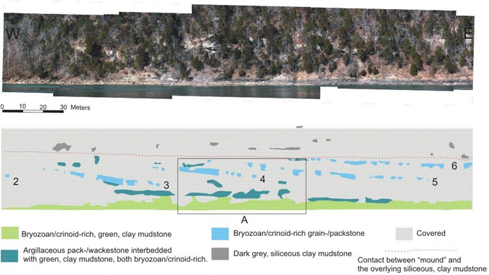
Figure 1. Image and interpretation of the Fort Payne Formation at the Oak Grove Church locality,
Dale Hollow Lake, TN. Inset A is shown in Figure 2. Distinct gravity flows are labeled 1 through 6.
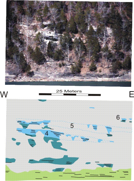
Figure 2. More detailed image and interpretation of the Fort Payne Formation
at the Oak Grove Church locality, Dale Hollow Lake, TN. See legend and location in Figure 1.
The vast majority of the bedding visible at this location is essentially horizontal. Inclined bedding occurs only within the bryozoan/crinoid-rich grain-/packstone facies (shaded light blue). This facies is interpreted to be the result of sediment gravity-flow deposition, based on the presence of Ta and Tb (Bouma) sedimentary structures. We hypothesize that the margin of the mound episodically slumped which created local inclined surfaces. These steeper surfaces then became the site for sediment gravity-flow deposits sourced from nearby topographic highs. The sediment gravity-flow deposits at this mound record six separate such events (labeled 4-6 in Figs. 1-2) and indicate that lateral progradation was important during the second half of mound construction.
Back to Field trip in the Dale Hollow region
Back to top of Geology of the Fort Payne Formation