
The Kentucky Geological Survey has archived this material, meaning (1) it is for reference, research, or recordkeeping; (2) it was created before April 24, 2026; (3) and the material has not been changed or altered since being archived. Please refer to our KGS Accessibility page for more information.
KGS Home > Geology of Kentucky
Lake Cumberland Debrite
Location: Along the south shore of Lake Cumberland, east of Wolf Creek, and across the lake from Timber Ridge road.
Nad-83 Decimal Degree (lat, long): 36.929003, -85.006628
7.5-minute Quadrangle: Jamestown (Thaden and Lewis, 1962)
County, State: Russell, Kentucky
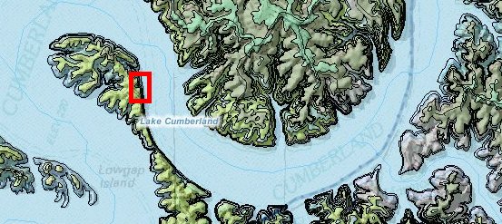
Figure 1. Location of debrites in the Fort Payne Formation, Lake Cumberland.
Overview: A Fort Payne matrix-supported conglomerate (diamictite), interpreted to be a debris flow deposit, or debrite, is exposed on the south side of Lake Cumberland east of the mouth of Wolf Creek. The face of the exposure is steep, so this deposit can only be viewed by boat. Figure 2 is a photomosaic of the exposure and includes more detailed images of the debrite. Only the upper part of the debrite is exposed at higher water levels, but the scour at the base of the flow and largest transport blocks are visible at low water level.
Photographs were taken on August 21, 2008, when water levels were low, at 680 ft. The upper part of the sandstone is exposed at high water levels.
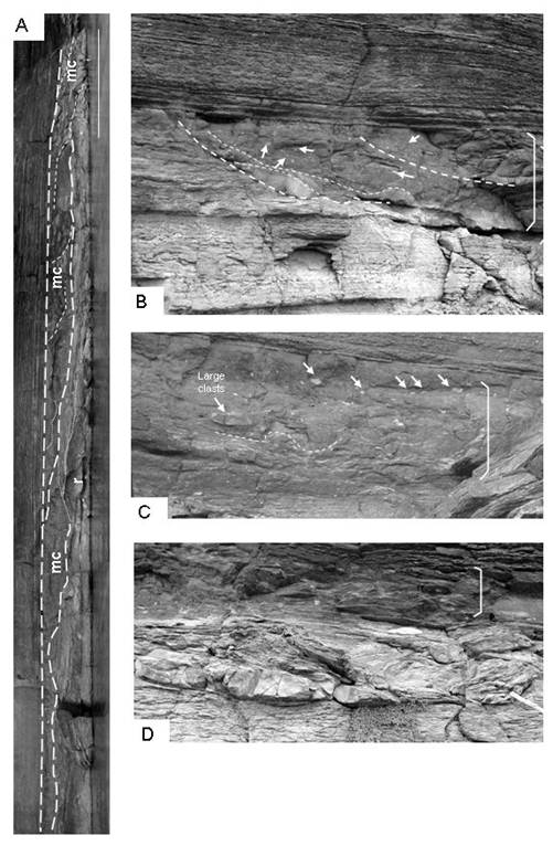
Figure 2. Matrix-supported conglomerates (mc) exposed on the south shore of Lake Cumberland.
(A) Photomosaic of the outcrop showing the succession of westward-accreting lenses that contain the conglomerate. Photomosaic is at relatively high water.
(B) The conglomerate (bracketed) is a mass flow deposit that contains internal slumps or scours (dashed lines) and large clasts (arrows).
(C) In some areas, large clasts appear to be concentrated along the top of the flow.
(D) Toward its terminus, the mass flow (arrows point to light-colored clasts) is underlain by a scour with soft-sediment deformation.
Lake level for B and C is 680.9 ft. From Greb and others (2008, Fig. 20).
Description: On the south side of the lake an extensive exposure of deformed bedding is exposed most of the year. The slope of the shore here is too steep to actually get out of the boats, but this long exposure is worth a close look. Figure 2 is a photomosaic of part of the exposure. A relatively flat-lying, sharp-based, dark siltstone to silty shale unit caps the exposure along its length. This unit is underlain by a series of westward-accreting packages of deformed bedding. Of particular interest is a matrix-supported conglomerate (mc), which looks somewhat like a diamictite. The unit is brown-gray, has a scour base, and contains abundant light-colored, angular clasts of varying sizes (Figs. 2B-C). There are also several large clasts of gray siltstone or silty shale, similar to the host rock (Figs. 2B-C). Along part of the exposure, large clasts appear to be concentrated along the upper surface of the unit (Fig. 2C).
At lower water level, the base of the conglomerate is exposed. The conglomerate sharply overlies a gray silty shale to siltstone unit, or a second interval of deformation, which includes rotated beds of the siltstone, as well as deformed carbonates (Figs. 2D, 3A-C). The most spectacular of the deformed carbonates occurs just beneath and east of the thickest part of the conglomerate (Fig. 3C). At this location, a west-dipping glide plane in the underlying siltstone or silty shale is filled with large, white carbonate blocks and gray, contorted siltstones. Silty shales beneath and to the front (west) of the carbonates are also deformed.
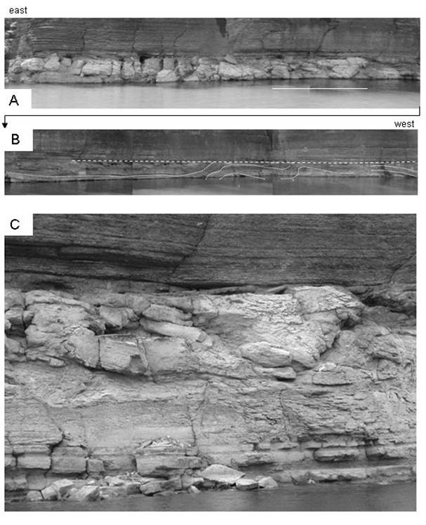
Figure 3. Lower interval of deformed beds. (A) Photomosaic showing the deformed zone with large, white blocks of carbonate and siltstone.
(B) At lower water level, the base of the slump or slide is exposed (location is white line in A, but only top of the feature is exposed at higher lake level).
Lake level for C is 680.9 ft. From Greb and others, (2008, Fig. 21).
Lewis and Potter (1978) noted the 20-ft-thick folded and slumped zone at this exposure and interpreted it as a submarine slide. Pebbly mudstones or fine-grained matrix-supported conglomerates can be formed in a variety of mass flows, but are commonly formed in debris flows and mud flows (Lowe, 1979; Mulder and Alexander, 2001). The deposits of debris flows are sometimes called debrites. Debris and mud flows are common in the type of distal ramp or slope environment inferred for deposition of the Fort Payne Formation (Fig. 4). Debris and mud flows and can travel downslope great distances from their source. They can also change character from debris flows to turbidity and other types of currents as they move downslope (see for example, Mulder and Alexander, 2001).
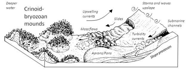
Figure 4. Model of lower Fort Payne deposition in the Lake Cumberland area showing varying slope processes that redeposited
sediment from the abandoned Borden delta downslope into the Fort Payne Formation.
From Greb and others (2008, Fig. 28). No scale inferred.
The debrites overlie another deformed zone, which is exposed at low water level. The deformed carbonates appear to be part of a large slump, or slump above a scour. They may represent updip units transported by turbidity currents or mass flows downdip of this location. Determining the relationship between this unit and the overlying debrite requires more work. It would be interesting to see if any of the clasts in either deposit could be matched to the updip strata from which they were derived.
References
Continue to Wolf Creek paleochannel
Back to Fort Payne Formation Field Trip in the Lake Cumberland Region
Back to top of Geology of the Fort Payne Formation