
The Kentucky Geological Survey has archived this material, meaning (1) it is for reference, research, or recordkeeping; (2) it was created before April 24, 2026; (3) and the material has not been changed or altered since being archived. Please refer to our KGS Accessibility page for more information.
KGS Home > Geology of Kentucky
Pleasant Hill Mound, Caney Creek
Location: On Lake Cumberland, at the intersection of Caney and Wolf Creeks, near the Pleasant Hill boat ramp.
Nad-83 Decimal Degree (lat, long): 36.955119, -85.005597
7.5-minute Quadrangle: Jamestown (Thaden and Lewis, 1962)
County, State: Russell, Kentucky
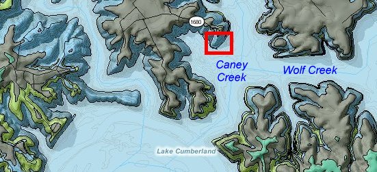
Figure 1. Location of the Pleasant Hill mound and geology of the area.
From the Kentucky Geological Survey's geologic map information service, based on Thaden and Lewis (1962).
Overview: The Pleasant Hill mound is exposed at low water level along Lake Cumberland. It is just east of the Pleasant Hill boat launch (via Ky. 1680) and is one of the few Fort Payne mounds that can also be accessed by road. This mound is described in stop 1 of Lewis and Potter (1978), and has also been discussed in Ausich and Meyer (1990), Meyer and Ausich (1992), Meyer and others (1995), and Greb and others (2008). Reefal limestones are shown along the shore on the Jamestown 7.5-minute geologic quadrangle map (Thaden and Lewis, 1962), although these mounds were not true reefs, and some of what was mapped as reefal limestones may include carbonates above the buildups. The mound or buildup geometry is not obvious as originally mapped, but can easily be seen in exposure. Lateral exposures along the shoreline show the core shale, carbonate flanks, and capping strata of this buildup.
Photographs were taken on May 18, 2008. Water level was 681.6 ft. The top of the carbonate flank of this mound is approximately 695 to 700 ft.
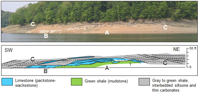
Figure 2. Interpretation of the Pleasant Hill mound, Fort Payne Formation,
from Lake Cumberland, showing core shale (A); flanking carbonate mound (B),
which were originally mapped as reef limestones (Thaden and Lewis, 1962);
and overlying green shales, siltstones, and interbedded carbonates (C). Vertical scale is approximated.
Description: The Pleasant Hill mound shows several typical features of Fort Payne mud mounds (buildups) in the area. First is a green glauconitic core shale (A in Figure 2), which is thick in the middle and thins toward the margins. The shale is overlain by thick carbonates on either flank of the core shale (B in Figure 2). The buildup is overlain by silty shale, siltstone, and thin beds of dolomite (C in Figure 2). These overlying beds are slumped and rotated off either flank of the mound. The base of the mound is not exposed, even at lowest water levels.
Continue to Greasy Creek mound
Back to Fort Payne Formation Field Trip in the Lake Cumberland Region
Back to top of Geology of the Fort Payne Formation