KGS Home > Geology of Kentucky
Capping Strata, Pleasant Hill Mound
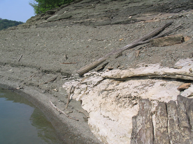
Figure 15. Green shale and dolomite beds draping carbonate mound (white).
Glauconitic green shales and interbedded mudstones cap the Pleasant Hill mound (Fig. 15). The capping units are exposed even at high water levels. From the lake, capping layers on both margins of the mound overly large listric glide planes dipping off of both mound flanks (Figs. 2, 16). Thin dolomitic interbeds contain quartz geodes and abundant crinoids.
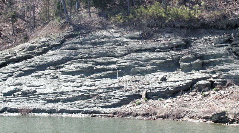
Figure 16. Slumped green shales and siltstones along the western margin of the underlying carbonate mound, showing slight rotation off of the mound.
References
- Ausich, W.I., and Meyer, D.L., 1990, Origin and composition of carbonate buildups and associated facies in the Fort Payne Formation (Lower Mississippian, south-central Kentucky): An integrated sedimentologic and paleoecologic analysis: Geological Society of America Bulletin, v. 102, p. 129-146.
- Greb, S.F., Potter, P.E., Meyer, D.L., and Ausich, W.I., 2008, Mud mounds, paleoslumps, crinoids, and more; the geology of the Fort Payne Formation at Lake Cumberland, south-central Kentucky (field trip for the Kentucky chapter of the American Institute of Professional Geologists, May 17-18, 2008): 45 p.
- Lewis, R.Q., Sr., and Potter, P.E., 1978, Surface rocks in the western Lake Cumberland area, Clinton, Russell and Wayne Counties, Kentucky (guidebook and roadlog for Geological Society of Kentucky 1978 field conference): Kentucky Geological Survey, ser. 10, 41 p.
- MacQuown W.C., and Perkins, J.H., 1982, Stratigraphy and petrology of petroleum-producing Waulsortian-type mounds in Fort Payne Formation (Lower Mississippian) of North-Central Tennessee: American Association of Petroleum Geologists Bulletin, v. 66, p. 1055-1075.
- Meyer, D.L., and Ausich, W.I., 1992, Fort Payne carbonate facies (Mississippian) of south-central Kentucky: Ohio Division of Geological Survey, Miscellaneous Report No. 4, Field Trip 14 for the Annual Meeting of the Geological Soicety of America, Cincinnati, Ohio, October 26-29, 20 p.
- Meyer, D.I., Ausich, W.I., Bohl, D.T., Norris, W.A., and Potter, P.E., 1995, Carbonate mud-mounds in the Fort Payne Formation (lower Carboniferous), Cumberland Saddle Region, Kentucky and Tennessee, U.S.A.: Special Publications International Association of Sedimentologists, v. 23, p. 273-287.
- Thaden, R.E., and Lewis, R.Q., Sr., 1962, Geology of the Jamestown quadrangle, Kentucky: U.S. Geological Survey, Geologic Quadrangle Map GQ-182, scale 1:24,000.
