| Topography | ||
|
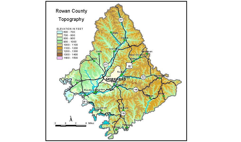
Discussion from McGrain and Currens (1978) The topography of Rowan County represents a mixture of the Highland Rim and the western edge of the Eastern Kentucky Coal Field. It is a well-dissected upland area, drained by numerous small streams. The Licking River forms the western boundary of the county, and the drainage of the county flows into it by the way of southwest-oriented valleys. Flat-topped ridges and bedrock terraces associated with resistant strata are present in the western part of the county. Except for these areas and the valleys of the principal streams, little flat land can be found. Most of the county can be described as hilly to mountainous. In the southeastern part of the county some of the high ridges and mountains are capped with resistant sandstones that have produced vertical or nearly vertical bluffs. The highest elevation in the county is Limestone Knob, located about 3 miles southwest of Morehead. Limestone Knob is 1,435 feet in elevation, more than 700 feet above the valley of Triplett Creek, which is less than a mile to the north. Clack Mountain, 2 miles south of Clearfield, has elevations in excess of 1,320 feet; Sugarloaf Mountain, 5 1/2 miles north of Farmers, is 1,356 feet. The knob on which Triangle Lookout Tower is located, 2 miles east of Morehead, is at 1,386 feet. The lowest elevation is 625 feet, the point where Licking River leaves the county. A flood-control structure has been constructed upstream from Farmers to create a reservoir in Licking River Valley. The reservoir, designated Cave Run Lake, has a normal pool level of 730 feet and a maximum flood pool of 765 feet. The elevation of Morehead, the county seat, is 748 feet. Other elevations include Clearfield, 740 feet; Cranston, 769 feet; Farmers, 670 feet; Haldeman, 940 feet; and Tollesboro, 816 feet. The 7.5-minute topographic quadrangle maps that cover the county are shown, by name and by index code (Kentucky Natural Resources and Environmental Protection Cabinet) on the index map. Previous--Next--Back to "Groundwater Resources in Kentucky"
|
||