| Topography | ||
|
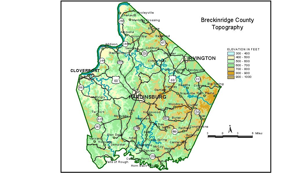
Discussion from McGrain and Currens (1978) Breckinridge
County is located in the Mississippian Plateaus area of northwestern
Kentucky. The Ohio River forms the northwestern boundary of the county;
the Rough River and part of Rough River Lake mark the southern boundary.
The lowest elevation in the county is the Ohio River at 383 feet. The
elevation of the Rough River where it leaves the southwestern corner
of the county is approximately 415 feet. A plateau area west of the sinkhole plain is marked by a conspicuous
escarpment that rises 200 to 250 feet above the plain. The plateau,
which is generally higher in the east than in the west, is moderately
to deeply dissected. Large flat-topped ridges are present in several
parts of the county. These flat areas, developed on resistant rock formations,
give these regions a tableland appearance. Locally isolated hills or
ridges rise 80 to 100 feet above the plateau surface. The Rough River,
Clover and Sinking Creeks, and other smaller streams are entrenched
100 to 150 feet below the upland. Entrenchment is greater near the Ohio
River. The highest elevation is approximately 920 feet, and is in the high
plains area of the extreme eastern part of the county, on the drainage
divide between tributaries of the Ohio River and Rough River. The greatest
local relief is in the vicinity of the Ohio River. In the northeastern
corner of the county, the difference in elevation from one hilltop to
the Ohio River floodplain is 500 feet over a distance of about 3/4 mile.
Locally, precipitous cliffs are present along some of the streams. The elevation of Hardinsburg, the county seat, is 714 feet. Elevations
of other communities are Cloverport, 411 feet; Custer, 824 feet; Glen
Dean, 466 feet; Harned, 755 feet; Irvington, 620 feet; Lodiburg, 520
feet; Madrid, 773 feet; McDaniels, 670 feet; and Stephensport, 423 feet.
The elevation of Rough River Lake at normal pool level is 495 feet. The 7.5-minute topographic quadrangle maps that cover the Breckinridge
County are shown, by name and by index code (Kentucky Natural Resources
and Environmental Protection Cabinet), on the index
map. Previous--Next--Back to "Groundwater Resources in Kentucky"
|
||