| Topography | ||
|
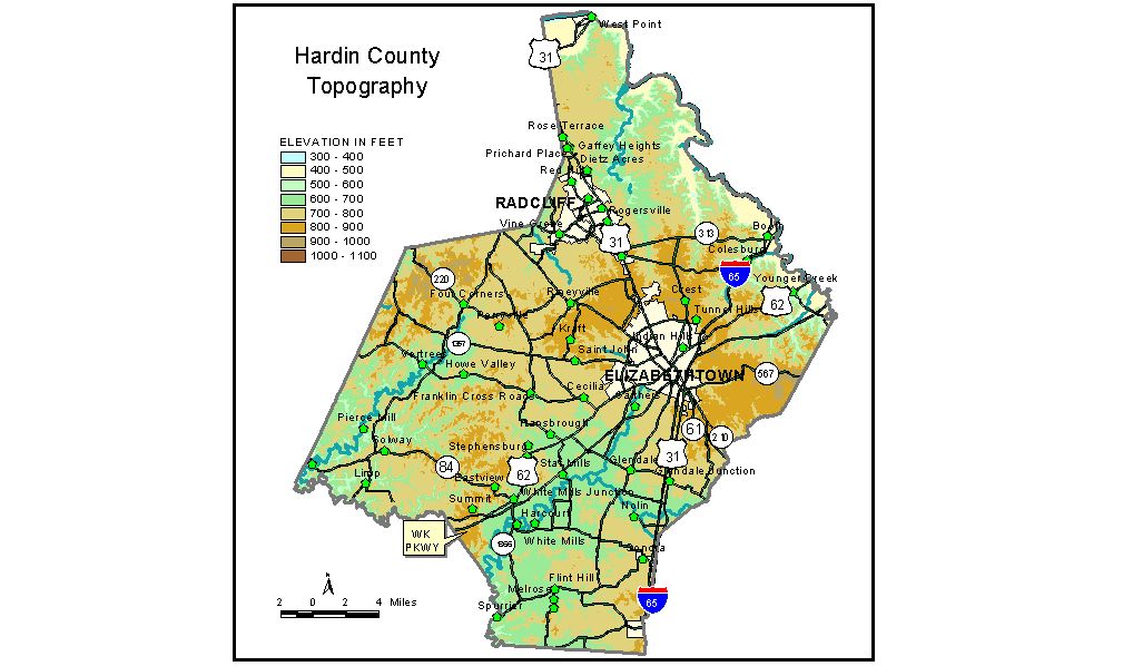
Discussion from McGrain and Currens (1978) Hardin
County, situated largely in the Mississippian Plateaus area of Kentucky,
contains a diversity of topographic features. Rolling Fork, which marks
the eastern boundary of the county, occupies a broad, flat valley near
the edge of Muldraugh Hill (Highland Rim escarpment). Adjacent hills
and ridges rise 300 feet above the valley floor. This well-dissected
upland, with ridgetop elevations of 800 to 900 feet, is part of the
knobs country. The Dripping Springs escarpment marks the boundary between the low
sinkhole plateau and a higher tableland to the west. The rise is approximately
200 feet. This upland, with elevations of approximately 850 feet in
the east and about 750 feet at the western edge of the county, is dissected
by normal stream drainage, incised about 200 feet. Broad, flat-topped
ridges occupy areas between narrow stream valleys. Resistant rock formations
make the valley walls steep; cliffs are present locally. The highest elevation in the county, 1017 feet, is on Blueball Hill, an isolated ridge on the karst plain about 4 miles northeast of Howe Valley. The lowest point, 383 feet, is the normal pool level of the Ohio River at the north end of the county. The elevation of Elizabethtown, the county seat, at the intersection
of U. S. Highways 31 -W and 62, is 731 feet. Elevations of other communities
are Cecilia, 709 feet; Colesburg, 450 feet; East View, 830 feet; Glendale,
709 feet; Godman Airfield at Fort Knox, 734 feet; Radcliff, 763 feet;
Sonora, 720 feet; Stephensburg, 687 feet; Summit, 852 feet; Upton, 744
feet; and Vine Grove, 682 feet. The normal pool level of Rough River
Lake, which touches the extreme western end of the county, is 495 feet. The 7.5-minute topographic quadrangle maps that cover the county are
shown, by name and by index code (Kentucky Natural Resources and Environmental
Protection Cabinet) on the index
map. Previous--Next--Back to "Groundwater Resources in Kentucky"
|
||