| Topography | ||
|
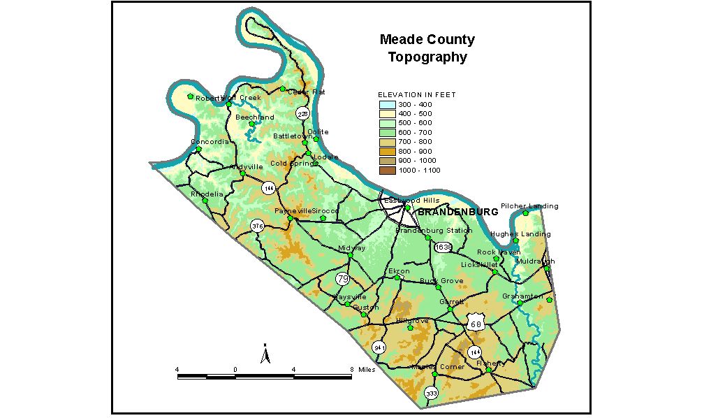
Discussion from McGrain and Currens (1978) Meade
County is in the Mississippian Plateaus Region of northern Kentucky.
The Ohio River marks the northern boundary. The normal pool elevation
of the river, 383 feet, is the lowest elevation in the county. Differences
in elevation between the river and the adjacent uplands commonly approach
or exceed 300 to 400 feet. Northwestern Meade County occupies part of a higher plateau. It is separated from the sinkhole area by the Dripping Springs Escarpment, an east-facing cuesta. Elevations at the edge of the escarpment are about 800 to 850 feet. The upper plateau surface declines approximately 100 feet to the western edge of the county. The surface is dissected by normal stream drainage, and karst features are rare except in valley bottoms. The valleys are narrow and deeply incised, commonly with local reliefs of 250 feet. The intervening ridges are generally flat topped. A large valley loop at Wolf Creek, carrying only minor drainage, is a conspicuous topographic feature. It was once a meander of the Ohio River, which has been abandoned. The "island" (meander core) in the center of the loop rises more than 300 feet above the encircling valley. At Brandenburg, the county seat, the elevation on the floodplain is 420 feet; elevation at the edge of the bluff is 550 feet. Other elevations are Battletown, 700 feet; Big Spring, at the junction of Meade, Hardin, and Breckinridge Counties, 680 feet; Flaherty, 793 feet; Garrett, 684 feet; Guston, 698 feet; Muldraugh, 720 feet; Paynesville, 816 feet; and Wolf Creek, 427 feet. The 7.5-minute topographic quadrangle maps that cover Meade County
are shown, by name and by index code (Kentucky Natural Resources and
Environmental Protection Cabinet) on the index
map. Previous--Next--Back to "Groundwater Resources in Kentucky"
|
||